Into the Green Mountains…

Screen Shot 2019-09-10 at 5.13.19 PMIMG_1938We continued our northward path from Massachusetts into Vermont. Having visited Woodstock, NY, a few weeks ago it was only appropriate we were near to Woodstock, VT. Closer to White River Junction but we spent all our time in and around Woodstock. The KOA we stayed at, Quechee/Pine Valley,  was a very nice KOA: clean, great staff, close to neighbors…predictable. My personal preference is to take chances with the state and national parks but this was fine.

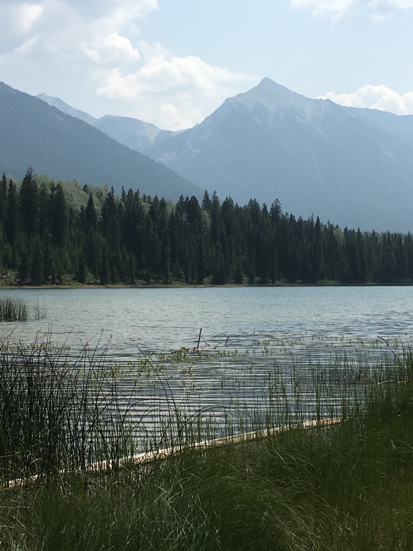
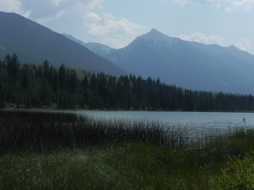
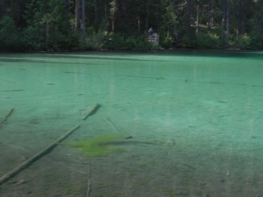
This campground is a few miles from Quechee Gorge, “Grand Canyon of Vermont”. That might be a bit overstated, but it was gorge-ous and made for a nice walk from end to end on Sunday after we set up at the KOA. Upstream is a dam with one of many small-scale hydro plants all over the region – this one at 1.8MW (much higher than I would have guessed looking at the transmission lines!).

As anyone who’s been there knows, the view from the bridge was spectacular and 163 feet above the river. Tough to show scale in photos, but this pair will give you an idea. Look closely at the left-hand “close-up” and you’ll see a person walking near the big puddle at top of the picture. Same view as the other photo but not zoomed in.

IMG_1915It’s always fun having visitors over for dinner, and especially fun to combine that with some quality time with a good friend from years-gone-by. On Sunday after our walk in the gorge, Ed drove up from his home in NH and joined us for some great pizza and wonderful conversation. Fun stuff.

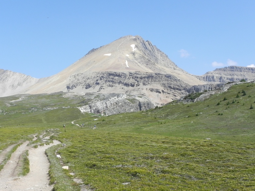
Monday after coffee and a scone at Mon Vert (great recommendation, Seth!) we “climbed” Mount Tom, an easy hike along trails set up by Marianne Faulkner over 75 years ago as a tribute to her husband. Interestingly, the lower serpentine trail was set up as a “cardiac trail” following a similar hiking trail she’d seen in Badin, Germany. It connects to trails and carriage roads as part of the Marsh-Billings estate. Note the dogs’ leash tied to the horse tethering post at the top of the trail. The weathervane was on top of an adjacent house which must have been her house. Pretty cool.

DSCN3332
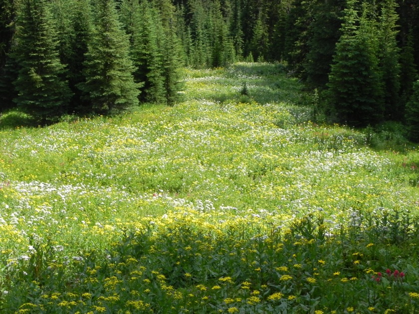
This was particularly interesting…along the trail a large tree had fallen, probably due to a wind storm at some point. It’s a bit tough to see in the photo, but when the tree fell it opened up the forest floor and all sorts of wildflowers sprang up. There’s a clear difference between the undergrowth in the forest and what started growing when the sun was allowed to shine. Great example of what we’ve all heard about.

IMG_1920Lunch was at Long Trail Brewery, a fun spot along a stream complete with corn hole (and some great food and beer)! They’re one of the Vermont breweries that distributes widely in NC, so fun to get to the mother ship.

After lunch we headed to Marsh-Billings-Rockefeller National Historic Park. Hard to think of another place we’ve been that combines spectacular hiking trails, fascinating mansions, lots of history and a working farm. Spent Monday afternoon walking around the farm, checking out a milking demo with their award-winning Jersey cows. Frederick Billings, 2nd owner of the farm and estate, brought them from the British island of Jersey for their high milk-fat content…which now helps make Vermont a great ice cream and cheese state. First owner, George Perkins Marsh was, among many other things, an author of “Man and Nature“, still in print and considered the foundational book of the conservationist movement. Third and final owners were Mary (Billings) French Rockefeller and Laurence Rockefeller. The working farm traces back to the original vision of both Marsh and, moreso, Billings as a model of productive, progressive farming practices to help Vermont rebuild its farming industry. That large fancy house was the caretakers and included a butter-making area with water-powered butter churn. The sunflower maze was at its peak – maybe 15′ tall flowers (check that picture with tiny April next to the giant sunflower) and a lot of fun to walk through!

The next day we took a tour of the original house which, similar to the Rockefeller’s Kykuit we toured in Sleepy Hollow, is remarkable in having furniture, wall coverings, books, art and knick-knacks from all the generations that lived there.

The town of Woodstock, Vermont, and the surrounding area is terminally quaint – quintessential New England. So many stylish houses, great views of the mountains, white churches, etc. While we were walking up Mt. Tom Monday we could hear the church bells chiming the hour…bells that were cast by Paul Revere. You can’t make this stuff up!

Today we shift from northward to eastward, heading to New Hampshire!

Into the Berkshires…

Screen Shot 2019-09-06 at 5.57.30 PMHard to imagine a greater variety of experiences over this segment of our trip. Lots of very interesting and fun stops. Highlights were a fun reunion with many of our close college friends and buying an all-electric eGolf, coupled with visits to museums, gardens, great food, etc.

IMG_1870Our first stop after Croton Point was in the driveway of dear friends Pierre (aka, Peter) and Martha who hosted a gathering of some of the “you guys” Tufts crowd. Always so relaxing and comfortable getting together with friends you’ve been close to for many years. Wonderful food (including smoked ribs and salmon), drink (including various bourbon concoctions), and great conversation.

IMG_1879After setting up at our site at Cozy Hills Campground, we stopped at White Flower Farm, which April has known about and purchased from for years. Their “demonstration garden” was absolutely stunning and is worth a visit any time.

I lucked out on this shot of a monarch butterfly on some sedum flowers.DSCN3297

IMG_1877

Past trips out west have included longer drives during our travel days – usually 3-5 hours. That supported a fun routine of breaking camp around 9-10, driving a few hours, finding a cool spot for lunch along the way and getting to our destination around 2-3. Our New England trip will have point-to-point drives in the 1-3 hour range so we won’t have the funky, cool, surprise lunches of past trips. No worries! Courtesy of the BTB restaurant in Edgartown, we’ve discovered muenster-and-kimchi grilled cheese, so all is good. And lunch in doesn’t deter us from fun dinner menus, including this tomato tart with fresh tomatoes from my brother’s garden in Haverstraw, NY. Yum!

The drive from CT to MA took us through some gorgeous rolling hills, including a long stretch on Hwy 8 and a branch of the Farmington River – stunning, and so typical of New England scenery around the area.

DSCN3308

IMG_1880Once established at our site at Fernwood Forest Campground, we headed into Northampton to buy a VW eGolf at the VW dealer there. Long story which I’d be glad to share with anyone interested, but it fits us well. To answer your first and second questions, they don’t sell them in NC, and we’re having it shipped to Raleigh…

It has turned cold for the nights here, a combination of the weather, altitude and latitude – this is inspiration for baking homemade scones in the morning to warm the place up. This batch was of the cinnamon walnut chocolate chip variety.

img_1883.jpg

Thursday brought us to the Hancock Shaker Village just west of Pittsfield, MA, and not far from the NY border. We’ve all heard of the Shakers, but I wasn’t familiar with their fascinating history. “…their main religious tenets: celibacy, communal life, and confession of sin. The Shakers also believed in racial and gender equality, simplicity, and pacifism.” Sounds pretty good, except the celibacy part which worked out ok after the Revolutionary War killed off a lot of men in the late 18th century but is not the best strategy to build and maintain a population. There are three Shakers left – in Maine. This particular village and farm was established in 1784 and preserved as a museum in the ’60’s. It’s an amazing collection of working exhibits from its heyday in the 19th century.

Particularly interesting – to me – was the original water works that included a hand-dug reservoir, race, and turbine (which replaced the water wheel in 1858). Makes about 4hp and should be strong inspiration for anyone considering a micro hydro electric generator….

DSCN3317
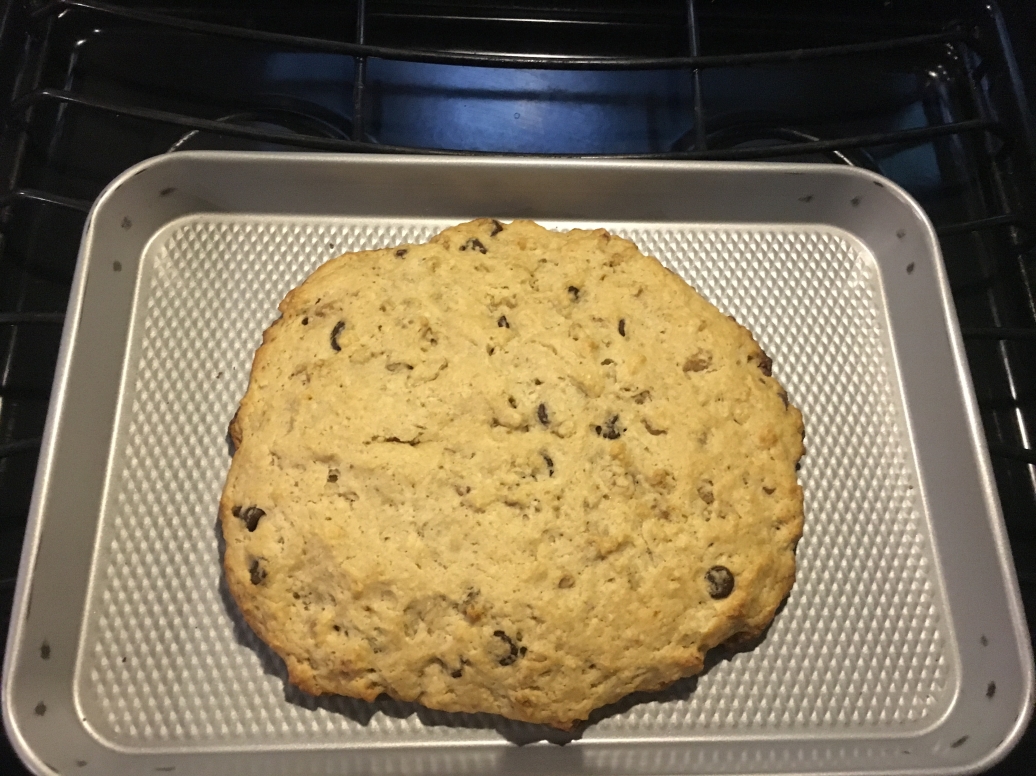
Next stop was the Berkshire Botanical Garden, which was as spectacular as you’d expect. Small, but with a unique variety of history, diverse themed gardens and lots of labeled plants. April was in heaven…

Saturday we finally got to use the bike rack accessory I bought to use the trailer-mounted rack for carrying our bikes on the car. Works great! Drove to the trailhead for the Ashuwillticook Rail Trail in Lanesborough for an 11-mile ride up to Adams. We’ve done some bike trails like this but not enough, and this one was stunning. Took us past lakes, through forest and past many of the old factories in the area – mostly textile mills.

IMG_1904Lunch in Adams, at the north end of the trail, was at AJ’s Trailside Pub. April got some shrimp but I feasted on “Pete’s World Famous Hot Moose Knuckle Sandwich”. Yep, it was as messy and delicious as it looks – glad we had another 11-mile ride back, to work some of it off.

IMG_1907Drove to Dalton for a flight at Shire Breu-Hous with a Gose, Imperial Milk Stout, Red Ale and Coffee Stout – all delicious, of course.

IMG_1912

Next door was Silver Bear Distillery, and we first met the owner, Bjorn, and his 6 month-old puppy in the parking lot then stayed and chatted with him during a tour and some tastings. (T&L, per the NCA, all vodkas are gluten-free!) No pictures (!!) but came away with a bottle of the unique “Barely-Filtered” Vodka, now in the freezer.

Today we leave our site in the woods and cross another state line, this time to near White River Junction, Vermont!

IMG_1910

Croton Point Park: 15 days in one spot!?

IMG_1852Our normal travel routine is to stop 2-4 nights, see whatever we came to see and move on. This certainly doesn’t work for everyone but works well for us. There is always so much to see, so many places to go and the journey is as important as the destinations. But when one has the chance to babysit their first (or any!) grandchild, all that changes.

IMG_1772There is a wonderful county RV park at Croton Point (8.8 miles from the house I grew up in), very convenient to drive to our daughter and husband’s house to help out. We worked in several fun excursions to the time here, and we’ll obviously be back. Croton Point is big and it’s a favorite spot for birders. I happened on a flock of birders a-twitter over sighting a Western Kingbirdcheck out the range and you’ll see why this was unusual (and I saw it, too!). There are also a surprising variety of trails, park lawns and bike paths, along with lots of interesting history.

Spent a day in “The City”, visiting the Museum of Art and Design, and the Guggenheim, whose architecture is almost more interesting than the art. We did a lot of walking, from Grand Central, the Garment District, MAD, through Central Park to the Guggenheim. That SUV was in front the Bank of China building in a long line of black SUVs…got a kick out of the license plate: BLK SUV.

Over the weekend we were joined by Seth’s parents and, among other fun meals and activities, went for a train excursion up to Beacon with a visit to a modern art museum, Dia: Beacon. Then an excellent lunch at Homespun Foods and some brews at Hudson Valley Brewery.

Those who know the area, know that Westchester County in the lower Hudson Valley is not only gorgeous but fascinating. Lots of money flowed up from New York City in colonial days and later. Frederick Philipse ended up with 81 square miles of land in what became most of Westchester, and Philipsburg Manor is about 100′ from Lauren and Seth’s house. Went to the Cornucopia festival there with lots of kid-oriented corn-y activities.

Another related estate on a much grander scale is Kykuit, the main house and property of the Rockefellers for four generations. John D Sr., John D Jr., Nelson Sr., and his children. Having grown up near here when we explored more accessible (i.e., easier to sneak into) areas of the property, it was absolutely amazing to see even a part of the house and grounds. So many fascinating aspects of the place, one being the museum-grade art collection. If you haven’t been, go when you get a chance. Note the view of the Hudson and Palisades…there’s a story behind how spectacularly natural it still is.

IMG_1786Another landmark when I was growing up was the local diner where we’d go for very-late-night snacks. At the time it was called The Briarcade and at some point was renamed The Landmark Diner. Driving past it on Thursday afternoon, it had burned to the ground!

Today we leave our grandson (oh, and his family) behind and head off on a loop through New England. First stop is a friend’s driveway in Easton, CT, for a little reunion of some college friends. FUN.

In (and out of) the Adirondack Woods

img_1693.jpg
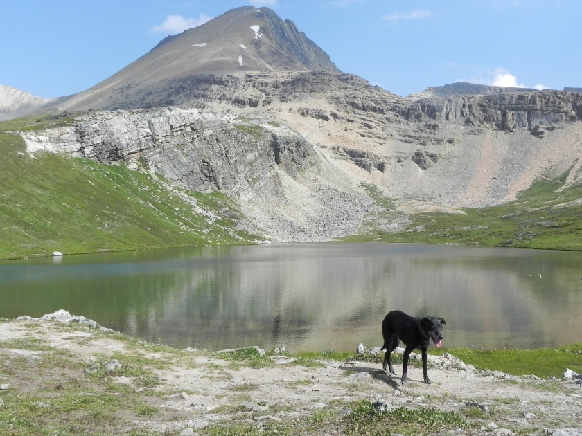
It’s the smell. We all have deep memories triggered by certain smells and where we visited in the Adirondacks is that for me. A unique mix of damp, piney hemlock mixed with whatever always reminds me of summers spent at camp near here when I was 7 to 10 years old. More on that later. The Adirondacks have a unique feeling about them: pine and deciduous woods, lots of lakes and ponds, randomly-spaced hills and mountains, and a sense of history as an early destination for vacationers from the Northeast.

IMG_1735Our next stop after Robert Moses SP, Buck Pond Campground is far from anything other than lakes and mountains, just north of Saranac Lake and Lake Placid in the northern part of the Adirondacks. It’s described on the website as a mountain retreat, which it is in all the best ways. All of the campsite loops were on or near water with well-spaced sites surrounded by woods, and quiet. Very quiet. When we come back, sites 89, 94 and 96 are spectacular, with gorgeous lake views. R&C, I’m afraid it’s not a good place for the bus. These pictures were all taken in or near the campground:


On Thursday, August 15, we took an early hike up St. Regis Mountain, one of an endless number of options for great hikes. The dogs loved it, the bugs were not nearly as bad as the reviews made them out to be, and the 360 degree view from the top of a fire tower was incredible. Look closely – it’s so consistently green and blue (sky and lakes) it almost seems like I spin around more than once.


In the afternoon I visited a nearby camp that I had attended when I was 8-10 or so years old, Adirondack Swim Camp for Boys – which is where the smell of the woods here was locked into my brain. Amazing that it’s still in the original family though they’ve understandably converted it to more of a VRBO spot using 4 of the original cabins converted to be comfortable for families. I didn’t remember much of the buildings or layout but it certainly brought back wonderful memories. (You’ll see my name on the far left in Lakeside cabin if you zoom in on the picture of the 1965 roster.)


Friday after a trip to town for coffee and some online-time, we rented a canoe then paddle board for the full mountain-lake experience. And we were rewarded, with three loons that let us get pretty close, and a deer munching in the woods nearby – on top of the peaceful quiet that is everywhere in this place.


Some have asked about our routine, and it usually includes some late afternoon down-time with a drink, some reading, whatever. This is typical of what the pups do at the same time of day (and other parts of the day, too!):

IMG_1763

DSCN3216Saturday was a travel day to our waypoint stop at a KOA in Saugerties, NY (with cell service/internet!). Crossed the Hudson on the Rip Van Winkle Bridge and visited Olana, a spectacular estate home (1870) and property of famous Hudson Valley artist Frederic Church. There was only one slot available for the house tour so April got that one, but walking the grounds was itself amazing. Well worth a visit if you’re in the area.


IMG_1769Drove into the nearby town of Hudson for dinner and had trouble choosing among a zillion hip spots to eat. Ended up at Wm. Farmer and Sons, a restaurant and inn, and this was one of the best meals we’ve had in a long time. Sorry no photos of the food – the only available table was outside under cover, but a wild thunderstorm made for some interesting ambiance. I had the Rigatoncini with shimeji mushrooms and a corn puree spiced with saffron and other intriguing Eastern flavors, and April had similarly enchanting grilled eggplant.

Today we head off on the last short leg of this segment, ending up at Croton Point Park on the Hudson River, 20 minutes from our daughter, husband and grandson! They’re in the middle of house renovations so our 2-week stay will be in the trailer, the longest yet that we’ve lived in one spot. So much to do in that area, I’m sure the time will fly by in spite of our stationary mobile home. Fun!

Along the St. Lawrence River…

IMG_1644We’re not close to the northernmost latitude of all our travels, but it sure feels like it. Upstate New York – and much of the state – is of course a world away from the NY metro area and it feels like it. Long stretches of highway through forest, farmland and small towns. Robert Moses State Park is right on the St. Lawrence Seaway so our view from the trailer included a section with huge freighters taking taconite from the Iron Range to Quebec, a reminder of the history of this critical transportation and trade route with Montreal as a key hub.

IMG_1647

IMG_1648Monday took us across the border to Montreal to visit Seth’s aunt Diane, who gave us a wonderful brief tour of the old section and waterfront. Being in Quebec Province, everything was in French with most (not all!) signs also showing the English translation, but it’s definitely a French-centric culture vs the western provinces we visited last year. Coffee at the waterfront, wandered the shops in the area, then lunch at the Crew Collective in a restored Royal Bank of Canada building that looked like Grand Central Station. Stopped at an indoor market for maple syrup and couldn’t resist some cherry tomatoes (which were no problem at the US border!). Gathered the dogs for a wonderful long walk up Mont Royal with a stunning view of the city, then made our way to the best t-shirt shop (tresnormale) and world’s best bagel shop (that’s debatable, but they’re pretty tasty…St-Viateur Bagel Shop), both recommendations from Seth.

The trip back across the US border included a pleasant surprise – a repeat of a wonderful experience crossing into Canada near Thunder Bay last year. After a rather exciting drive through heavy rain showers, we pulled up to the guard booth near Fort Covington, NY. After the usual questions, he reached into a big box and pulled out dog biscuits and gave one to each of the eager pups. Prior to that crossing at Thunder Bay, more often than not Enzo and Chai would go nuts, barking ferociously – which didn’t make for a fun stop. After that Canadian Immigration guy, both dogs stare eagerly out the window for a treat…no barking! Nice that this guy provided some timely reinforcement for that behavior.

IMG_1667Tuesday was spent in-park, starting with a bike ride to the nearby Eisenhower Lock, with a drop of 47′ and one of 7 on the St. Lawrence Seaway that were completed in the late ’50’s. I hadn’t realized that this key shipping passage from the Great Lakes ports to the Atlantic was unavailable until then – interesting to wonder about the impact that had on shifting trade and industrial centers. We happened to get there when a huge taconite freighter was moving through – amazing to watch this huge ship and the lock do their thing.

IMG_1684Back to the trailer for lunch then a drive to the nearby Nicandri Nature Center and some nice walks on trails in the area. Saw this hornets nest hanging in a tree next to one of the trails, pretty cool watching them zip in and out but wouldn’t want one of those stuck on my nose. Some great views of one branch of the river.

IMG_1686

Last stop was the Moses-Saunders Power Dam, a joint US-Canada project completed in 1958 that produces a total of almost 2 GW of power (that is a LOT), divided between the two countries. This thing is impressive! I also liked the fact they had a line of 6 EV charging stations next to their empty visitor center.

IMG_1688

Next stop…Buck Pond Campground in the middle of the Adirondacks north of Lake Placid.

Big lake, big chasm, bigger history

IMG_1623Pulled out of the farm and back into the groove of trailer travel, with our first leg illustrating how “long” drives in the Northeast will be, say, 3 hours. A bit different than the out-west legs that might go 4, 5, or more. Drove up the Vermont side of Lake Champlain in order to stop by a battery store (mystery trailer battery situation) which meant we got a huge treat taking the Grand Isle-to-Plattsburgh ferry across the lake. On a stunningly beautiful day. Always fun taking the trailer on a ferry and more fun when it’s not outrageously expensive.


IMG_1639Pulled into Cumberland Bay State Park for one of the more challenging arrangements, with no designated parking pad or campsite boundary. No problem, it’s what we bring all those leveling blocks and boards for! Friday brought us to Ausable Chasm. We all have tourist spots we went to as little kids with the snippets of memories and this is one of those for me. Surprisingly, the general scene I remembered – walkway along a steep cliff with roaring river below – was accurate, with many more gorgeous views I’d forgotten.


DSCN3191Fascinating history, playing a big role in building tourism into the region in the 19th century well before car travel. The Adirondacks in general and Ausable Chasm in particular, were promoted through the photography of Seneca Ray Stoddard, who seems to have been to this region what Ansel Adams was to Yosemite and the West. Stoddard’s work led to the creation in 1892 of Adirondack Park, the largest publicly protected area in the lower 48. Another part of history in the region was a very active role in the Underground Rail Road and the North Star Underground Railroad Museum had many interesting exhibits, films, etc. that illuminated how divided the country was between Abolitionists and pro-slavery factions. Amazing how our knowledge of history is constantly being revised and expanded – the guide at the museum was a historian who recently co-discovered a 100 year-old letter by John Thomas, of his life as an escaped slave from Maryland who settled in the region, established a farm and prospered. (There is a lot more to it than that!)

IMG_1630After all that we headed into Plattsburgh for laundry and lunch – found yet another spectacular little lunch spot, The Twisted Carrot. Everything had its own delicious flavor: Potato-Cheddar Ale Soup, chicken sandwich, zucchini-chickpea burger, a white burgundy and even the iced tea!

Took that cute ferry across Lake Champlain again to visit Burlington and wander down Church Street Marketplace for the annual Sidewalk Sale. The number of outdoor stores like LL Bean, Eddie Bauer and several other brands gives away the demographic, with fun restaurants and shops everywhere. After a longer walk with the doggies to and along Waterfront Park, we headed to Citizen Cider for a flight and lunch.

Dodged occasional short rainshowers all day, but we were treated to a heavy squall just as we were getting on the ferry for our last crossing.

DSCN3202

IMG_1640Back “home”, April made another version of blueberry cake using just a portion of the blueberries picked before we left Richard’s farm. Yum!

Then after dinner, a walk along the beachfront of the campground, with some spectacular sun-draped cloud formations to the east and west.

IMG_1642

And today we head to our next stop in this Upstate (NY) Adventure, at Robert Moses State Park – Thousand Islands!


Our current adventure: Several short or one segmented trip?


Screen Shot 2019-08-07 at 9.12.15 PMCall it efficiency or laziness, but we actually started the trip we’re on back in late May and I’m just now cranking up the blog. Brief background…if you make your way to the last posting from April 8th, you’ll see the US map showing that we’ve camped in all states but the Northeast, and Oregon (that’ll be 2020). We have a lovely spot we go to on Martha’s Vineyard each year. And the biggest news is we now have a grandson who is in NY just north of the city. Combine all those and you’ve got a string of fun months for this year. The sequence: (1) Bring trailer to friend’s farm near Lake George, NY; (2) Two months on Martha’s Vineyard; (3) Return to trailer and spend 10 days in Upstate NY; (4) Babysit grandson for two weeks; (5) Tour New England; (6) Return to Raleigh.

IMG_1269Screen Shot 2019-08-07 at 5.35.42 PMThe first segment started just before Memorial Day, when we headed north with trailer in tow. Stopped at Pohick Bay Regional Park campground in Northern VA, our second and definitely not last stay there since it’s only about 30 minutes south of Alexandria – perfect for visiting and getting into DC.

Our second stop, Mahlon Dickerson Regional Park in northern NJ, was a very pleasant surprise,. About 30-45 minutes from the Tappan Zee Bridge, this was another spot that is amazing for how rural it is, so close to the largest city in the country. Very quiet, woodsy campsites, great running trails.

The big advantage of that gorgeous park is it’s about 45 minutes from this cute guy, though we’ll be staying at a closer place when we return for our babysitting visit in a few weeks.

IMG_1277 2

IMG_1297From there, we traveled further north to leave the trailer for a couple months near Lake George, which is an area with tons of Revolutionary War – and other – history. Between the wooded hills, dry-stack stone walls (which are telling signs of the many farms of centuries-gone-by), lakes, streams and waterfalls, this area has some of the prettiest and most interesting scenery in the country. We visited Fort Ticonderoga which, with other sites in the general area of Saratoga, played a pivotal role in turning the Revolution in favor of the Colonies (thank you, Richard, for loaning me the book Saratoga, with all the fascinating details of the Battle).

Had lunch at Bolton Landing Brewing Company and walked through one of the fancier resorts on Lake George, The Sagamore. Got to see the resort from the other side of the lake two months later!

After spending too little time on the Vineyard, we recently headed back to our house on wheels. On Richard’s recommendation, took a hike to Shelving Rock Falls on the eastern shore of Lake George. Descending from a dam that was part of a mill pond, the falls are spectacular, matching the scenery from where the trail descends to the Lake George shore. Took a refreshing swim in the lake before climbing back up to the trailhead.

Saw this mooring ring imbedded in a rock on the shore. Tough to tell the size in the picture, but it’s about 6″ in diameter. Look closely and see how the rock is worn away where the ring has flipped back and forth over the decades – or centuries. If this ring could talk…

DSCN3169

Today we continue the Upstate New York segment of this 2019 journey, heading to Cumberland Bay State Park on the western shore of Lake Champlain. On the road again!!

7,560 miles, 49 days, 14 states

We’ve already been home a few days but this post will wrap up this trip. Looking at the miles we’ve covered in the longer trips (total of 4 so far), we’ve unintentionally developed a pattern of about 1,000 miles per week. Not for everyone but for us the pace is good; most stays are 2-3 nights, with a few longer and some 1-night waypoints. There are occasions we feel it’d be nice to extend the stays but there truly is so much to see we enjoy moving on to the next great discovery.

A question we always get is to pick out our favorite. My response is always the same, that there are so many differences of sights seen, gorgeous views, fascinating history, delicious food, etc., that it’s not possible to pick just one. On this trip, the brisket at Heavy’s in Hondo, TX, was pretty darn good – again. The coffee shop in Silver City, NM,  was an island of funkiness. The porter (and bbq) at Brick Vault in Marathon, TX, was spectacular – particularly since this place is in the middle of absolutely nowhere. The essential and sobering lessons of both the National Memorial for Peace and Justice in Montgomery, and the National Civil Rights Museum in Memphis were priceless. The view from The Window in Chisos Basin at Big Bend NP was amazing, as was the view from The Notch at Guadalupe Mountains NP. But as I’m reminiscing, these examples are being eclipsed by so many other great memories, and I’m back to my cliché response.

This trip we had our second run at caravanning with close friends and relatives. The first time was a short trip in late October last year and I didn’t blog that week. That one was with 38-year friends and veteran RVers – and our inspiration to dive into this RVing world. This one was with April’s brother and wife on a maiden (rental) voyage as a trial for possibly buying something. I think they’re hooked. Lots of fun parking right next to folks we share drinks and meals with…community.

Next up for later this year is some wandering through New England and New York. Haven’t planned that one out and we’re looking forward to exploring a section of the country that I’m more familiar with, but not via travel trailer. This will knock out the remaining states we have not yet camped in in the Lower 48, with the exception of poor Oregon. (We keep wondering why we didn’t zip down there, at one point about 30 miles away on the last long trip!) This wasn’t a compulsive goal, but it’s not bad for 2 1/2 years of travel.

IMG_1078 2

Until next time….!

Elvis and Family

Screen Shot 2019-04-04 at 8.08.39 PM

Left Hot Springs, Arkansas, Sunday, March 31st and have covered some ground the past four days! Not our preferred pacing but it’s worked fine – and with our first grandbaby expected any time now, it’ll be good to be home and ready to go.

IMG_1083 2Plenty of flooding in the rivers as we got near Memphis. The park we were at, T.O. Fuller State Park, was close to the mighty Mississippi but no problems. Nice enough campground, older and with plenty of woods around. Fun hearing an owl cooing close by one night. One big attraction, of course, was a visit to see Elvis the afternoon we arrived. Our first visit to Graceland and it’s got all the hype and cheesiness you’d expect with a reasonable mix of interesting history and personal stories. Worth the stop (though marginally worth the $40 entry fee). Not surprisingly, no mention of his drug problems and cause of death. Plenty of enthusiasts, such as an older guy with an Elvis t-shirt taking selfies with his digital SLR (how he did that, I’m not sure) from various angles around the memorial.

IMG_1090 2The next day we headed to the Lorraine Motel and The National Civil Rights Museum. We’ve been to quite a few civil and human rights museums across the US and in Canada, and this was not the largest but one of the best. Of course the focus is on Martin Luther King, Jr., his involvement in the civil rights movement and legacy. They also wove in history and context to provide a full story. They have been able to preserve the buildings involved and lay out the tragic details of MLK’s assassination along with the range of surrounding theories. Afterward, we walked across the street for lunch at the famous Central BBQ and had some great brisket, smoked pork and incredible smoked sausage. 

IMG_1092
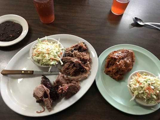
Next stop was Nashville, where the drive got us out of Mississippi flatland and into the rolling hills as a preview of the Blue Ridge Mountains. Note the redbud and other trees in bloom or early-spring shades of green. Beautiful! The Nashville stop gave me a chance to see several first cousins and my Aunt Sue, almost 97 years old. She is clearly looking older but doing remarkably well considering her age. Using expressions she was famous for (with me and Glenn), “Mercy on us, she’s MARvelous!” Saw cousin Lynne (what, no picture!?!) and Susan, and parked once again in Beth and Ross’s driveway – wonderful visit.

IMG_1111IMG_1110 2
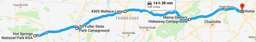
Continuing the sprint home, we crossed the state line and spent the night just east of Asheville in Swannanoa at Mama Gertie’s Hideaway Campground up a steep road then steep driveway with a great view of the valley below. Perfect private RV park and the entry on Patton Cove Road has a close family connection…

Last night of the trip, stopped at a new (8 months) brewery in a town I’ve been visiting for most of my life. Black Mountain Brewing has seven taps running as of January, a rich and flavorful Black Mountain Appalachian Wood Fired Stout, and exciting plans for expansion.

IMG_1118 2

Today we head to Raleigh.

(NE, KS, AR) It’s the little things…

IMG_1078 2
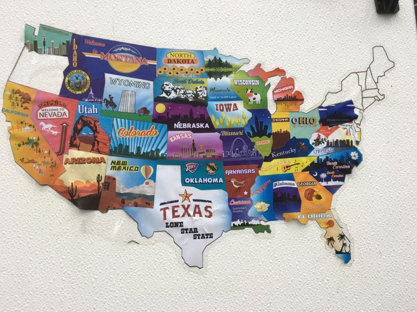
This segment of our current trip came with several fun surprises and a milestone. The milestone came with our stay in Arkansas, which meant in the past two years we’ve been to 38 of the lower 48 states, with the Northeast (later in 2019) and Oregon remaining. It hasn’t been an obsession to hit all the states, but it’s fun to think of the ground we’ve covered. The journeys will continue.

So what were the surprises? Another fantastic lunch find in a small, middle-of-nowhere town, a fantastic waypoint park, and a surprisingly complex National Park “town”.  Two very long driving days but all good.

The drive from Kearny, Nebraska on Thursday, March 28, covered some cliché Midwest prairie land and a surprising amount of wooded, hilly terrain. We’ve all seen fascinating highway cuts (and the books describing the geology of these cuts) but it was not expected we’d see them across these tornado-alley states.


img_1041.jpgOur lunch stop that day was determined in part by our need to find a tire repair shop. Yep, that’s flat #2 for this trip – not a good record. Found one of the trailer tires flat when we were prepping to leave Ft. Kearny, swapped with the spare in about 20 minutes (this involves emptying everything from the back of the Jeep including our generator so I can get to the jack) and got it fixed at Thompson’s OK Tire in Beloit, Kansas – as professional, clean, efficient and friendly a place as we could have found. If you have a flat near there, you now know where to go. To top it off, the place April found in Beloit, Bubba Q’s, had some great bbq brisket and pulled pork!

Then we got to our waypoint stop at Lake Crawford State Park (selected at the last minute) in the southeast corner of Kansas. All RVers and others take note (R&C, Hillary…) this should be on your list of places to stay. The lake has a rocky cliff shoreline, lots of great views of the lake and, for this runner, a perfect 5+ mile loop around the lake. And we were one of two sites occupied in the entire park of 83 RV sites. Wow.


We took the unusual step (for us) of stopping along the way from Lake Crawford, in Bentonville, Arkansas – home to WalMart, of course – at the Crystal Bridges Museum of American Art. Amazing what you can do with tons of money, and the Waltons put together an incredible museum. Besides a variety of art, fascinating architecture, and well-done historical context, they moved a Frank Lloyd Wright house from New Jersey and reconstructed it, piece-by-piece, in the perfect setting. Everything is less than 10 years old and very tastefully done.


Our stopping point was Hot Springs, Arkansas, which everyone has heard of. What we weren’t expecting was the depth of fascinating history and unique character (in a good way, not code for weird) of the place. It probably gets crazy crowded in the summer with amusement park, wax museum, etc., but worth a stop any time. We always think of Yellowstone as the first National Park but did you know Hot Springs National Park was the first federal reservation – set aside in 1832 before they had national parks? Of course Native Americans had been using the springs for much longer, but when “discovered” they became a major part of the healing craze of mineral and hot springs until the middle of the 20th century. One interesting (to me) factoid from our tour of the Fordyce Bathhouse is that the craze around baths as healing centers is, in part, medically sound. Before medicine had figured out how diseases or infections were spread, doctors in hospitals weren’t too concerned with washing between treating different patients. Baths, of course, involve lots of washing so were, in fact, healthier. Thus the popularity of baths as healing places!


Today we head to Memphis to stop in and see Elvis.

Sandhill Cranes on the Platte

Let’s start this off with an audio clip…click THIS LINK and I hope it works for you! (Let me know if it does. Video below has similar sounds of the sandhill cranes.)

Screen Shot 2019-03-27 at 4.06.45 PM

A key planned stop of this journey was to the largest congregation of sandhill planes on the planet, their migratory resting stop between wintering and summering habitats. Tough to imagine 4-600,000 large cranes in a small area but that’s what happens and Kearny, Nebraska, is the epicenter. Great recommendation from friend Wendy B and so glad we made the up/down sprint north.

IMG_1005
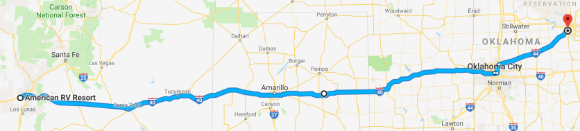
From Tulsa, we made a stop at a perfect (for a waypoint) community RV park at the Concordia Airport along Hwy 81 in Kansas. A bit noisy with truck air brakes going late into the night, but too much fun (for me) to run around the paved and turf runways in the morning. (Probably not allowed and not a good idea unless you’re familiar with GA ops and it’s 7am on a cloudy day.) About 5 bigger RVs pulled in at dusk and out early but otherwise it was us and one other trailer.

The scenery was lovely along this route through Kansas and into Nebraska. Rolling hills and plenty of trees along with many, many square miles of farmland – mostly corn. No sign of Dorothy or Toto.

Between Concordia and Ft. Kearny our route took us near the Geographical Center of the Continental USA so, with rolled eyes from April, we made a slight detour to go there. How cool is that??! (Enzo and Chai thought it was totally awesome!)

IMG_1014 2

Ft. Kearny State Recreation Area Campground is first come first served and the sandhill crane migration is a popular attraction so we were a bit concerned about finding a spot…but the place was mostly empty and Site #7 turned out to be one of our best ever with lake views front and back and lots of space to our neighbors. Nice!

DSCN2323Driving into the park, we were greeted by many flocks of sandhill cranes munching on grain in the cornfields, along with their unique vocalization: part chirp (like a cricket, sort of), part purr, part honk, and part something else. Here’s the video of some soaring nearby – turn up the sound for the full effect….

That sound is ever-present, often loud and crazy when we were in the blind Wednesday morning. If you’ve been to a symphony, imagine the pre-performance tuning when all instruments are going at the same time….a symphonic cacophony.

There are literally hundreds of thousands of cranes in the area for a few weeks in March, and their basic routine is to roost on the Platte River, crowding in the river or on clear sandbars to avoid coyote or fox. They’re fun to watch any time but most fascinating is when the fly in in squadrons of a few to hundreds, from daily feeding in fields near and far to roost for the night. Or when they take off in squadrons in the morning, which is what we signed up to see from Audubon blinds at Rowe Sanctuary. That involved getting up to be there by 6am, walking in and staying perfectly quiet while the cranes woke up and took off.

DSCN2433The Platte River (Rivière Plat, or flat river in French) itself has a fascinating history. It was a significant segment of several major emigration routes for wagon trains heading west in the mid- to late-19th century, such as the Oregon Trail and Mormon Trail. Ft. Kearny, adjacent to the campground, was one of the string of forts established to clear out the Native Americans and provide stopovers for the Pony Express and wagon train travelers.

Sandhill Cranes have been taking this migratory route and stopping in the area along the Platte River for thousands or millions of years. Yes, millions, based on fossil records – even before there was a Platte River. They are among the oldest living birds on the planet and the experience of seeing this migration is something to put high on your bucket list. There is also a big problem created by the steep (>70%) reduction in water flow of the Platte, narrowing what used to be a very wide, narrow river. This is apparently the origin of the expression “inch deep and mile wide” (cool, huh Jerry?) as described by early Caucasian explorers.

As you might expect, I took a lot of photos starting with an evening watching them fly in to land, from a bridge near the campground.

The estimated number along the river in the area we could see from the Audubon blind was 200,000 cranes. Imagine what that looked and sounded like – the photos are great reminders but don’t fully capture the scene.

DSCN2335DSCN2369DSCN2399DSCN2401DSCN2411

Tried to catch some in flight – when the rising sunlight caught the bottom of their wings it was magical.

DSCN2389DSCN2422

Today we continue on the path homeward, a long drive to the southeast corner of Kansas for a waypoint stop at Crawford State Park (livin’ on the edge with another try at a FCFS site!) then into Arkansas.

Waypoint surprises: Amarillo,Tulsa

Screen Shot 2019-03-24 at 4.17.36 PM

Two 4-5 hour drive days in a row on Friday and Saturday is not our preferred style, but at times it makes sense. (That’s normally a very short drive for us, but dragging a trailer is different than simply driving the car.) And it’s too much fun to stumble on unexpected gems to eat at, camp at or visit.

IMG_0944IMG_0943 2I-40 runs through Raleigh so it was interesting spending so many hours driving east and know if we kept going, it’d be Exit 283 and we’d be home. Lots of prairie, rolling hills, oil or gas wells, wind turbines and small towns on both days. At some point we passed a sign, “Hitchhikers May Be Escaping Inmates”. Seems if the hitchhikers may be escaping some inmates on the loose, it’d be a good thing to help them out by picking them up, eh?

IMG_0942 2April found our lunch spot Friday at a truck stop at I-40 exit 36 in Vega, Texas. Turned out to have some of the most authentic Indian food we’ve ever eaten, all delicious. This is a thing that make sense but we’d never heard of: apparently there are enough truck drivers who prefer Indian meals (presumably there are many Indian/Pakistani truck drivers) that there’s a network of these places. Buffet, water to drink, nothing fancy but great taste. Fun.

Pulled into Lake McClennan Campground at McClellan Creek National Grassland, our first in a string of no-reservation nights (First Come First Serve). Turned out the lack of reservation was not a problem, with only one other couple there. From Pryor Lake, Minnesota, in a small pop-up. Nice being so remote with so few others around, though the lake is bone-dry and the area is set up – and well-used – as a 4-wheeler’s paradise.


IMG_0952 2 
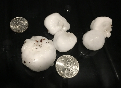
That night a thunderstorm rolled in. Watched it approach on radar with some concern…and the hail started. Our first experience with this type of bad weather, and you can imagine what it’s like to be in a small box in a hail storm. Scooped up some of the hailstones – that’s a nickel and dime in the picture. The video was shot out the  window and the audio doesn’t capture half the noise. No damage.


img_0958-2.jpgMore of the same terrain the next day on the drive to Tulsa, with more oil and gas wells. The next lunch stop was plain bizarre, in a phenomenal way. El Reno, OK, is about 30 miles west of Oklahoma City which puts it in the middle of nowhere. Small city, almost empty at mid-day on a Saturday. A bit eery, and walking into The Glass was like stepping into another world. Met the co-owner, Alec, who opened it two years ago as a combination art gallery, live music venue, wine bar and bistro. In El Reno. Alec is from London, spent early years in California running music studios for rock stars, and ended up in El Reno about 20 years ago. He’s got great plans, and I made a strong push talking to him about opening a craft brewery in town. The dill pickle soup sounded weird and tasted fantastic, as was the 4-cheese grilled cheese and chicken salad. Looking forward to visiting in a few years, eating NY style pizza, listening to great music and drinking one of those beers.


We decided to bail on our next FCFS site and find a place closer to town so ended up at Tulsa Warrior RV Park. Nothing special but perfect for what we needed. Tulsa, it turns out, is more than its long-term slogan, “The Oil Capital of the World“. Two incredible art galleries, one of several great brewpubs, one of many coffee shops (with a live DJ) and a walk in The Gathering Place along the Arkansas River – a full day of culture and cool vibes.

IMG_0969First stop was at The Gilcrease Museum, with a world-class collection of Native American and art from the American West. Not surprisingly, it was founded by wealthy oilman Tom Gilcrease who had amassed a huge collection of art and historical artifacts, just part of a fascinating history of the museum. Strong theme throughout, of the contributions of immigrants to the USA over the centuries.

IMG_0981 2Next was brunch at Prairie Artisan Brewpub with a saison, one of the 21 (mostly) house-made beers on tap. Seth’s recommendation and a great one. Then across the street to the Chimera Cafe for coffee. This section of Tulsa has an abundance of funky shops, with lots of Lime scooters and skateboards flying around. Fun.

The next stop was at the Philbrook Museum of Art, another fantastic mansion converted to a fantastic art museum. The grounds and gardens are worth the visit on their own, and the diverse collection of (mostly) paintings from various periods and artists is impressive. Then for a walk with the pups along the river and back to the trailer to watch Duke barely, barely squeak out a win against UCF.


Next stop we’re planning to be in central Kansas, but today may include a change of those plans. One of the key stops on this trip is to experience the sandhill crane migration at Rowe Sanctuary along the Platte River in south-central Nebraska. Got a notice yesterday that they’re closed due to flooding…if they cancel through Wednesday, we’ll change our plans. Flexibility is a good thing!

Pueblos, Petroglyphs and Paces

(April’s maiden name is Pace so of course that’s her brother’s name…couldn’t resist the alliteration.)

Screen Shot 2019-03-21 at 8.01.57 PMThe latest two stops at Bluewater State Park and in Albuquerque at American RV Resort finished up a wonderful week (March 14-21) with Tom and Renee, April’s brother and wife. They’re relative newbies to the RV lifestyle but seriously considering taking the plunge and it seemed like the experience was a good one. Had a good mix of weather, drive times, road types, overnight sites, food, sightseeing and all the other things that go into our life on the road. Fun stuff.

The drive from Silver City to Bluewater Lake (located along I-40 west of Albuquerque) was particularly interesting, with most of it through a variety of geology and terrain in Gila National Forest along the western border of New Mexico. The miles of hills of volcanic rock, the steep bluffs, snow-capped mountains, forests, etc. made for some great views as we rolled along in tandem. Lunch was at Ella’s Cafe in Reserve, NM, yet another incredible find in a small town in the middle of nowhere. All the food was great, but my St. Patrick’s Day special of corned beef and all the fixin’s was huge, delicious and perfect.

Bluewater Lake State Park was mostly empty and perched on a bluff over the mostly-empty lake with a great view of the dam. One of the best running trails for what I like with the dogs, about 1.5 miles down into a canyon and back up with two river crossings over rocks and logs. Chai loved taking the lead.

IMG_0918 2The next day was one of the best – took Cathy’s recommendation and drove the very long, bumpy, dusty road via the south entrance into Chaco Culture National Historic Park. The drive was the kind a Jeep (and its driver) love but it’s clear the north entrance is more popular. If you are ever in the area, this is a place to spend at least a full day at. The pueblo architecture is incredible, including clear evidence of 3+ story structures and a population that may have been up to 5000 in the period or 850-1250 A.D.

Took the hike from Pueblo del Arroyo up a steep and very narrow trail up the cliff to the Pueblo Alto Complex. This is a rare national park where dogs are allowed on the trails and both were amazing climbers, with a little help in a few spots.

Got a treat on the way out with a huge herd of elk grazing in several groups by the side of the park road. Beautiful to watch and they didn’t care we were a hundred yards away.

IMG_0930 2Albuquerque has more to see than a couple of days provides, but after we arrived Tuesday and got set up, the drive around town included a stop at the Santa Fe Brewing Taproom in Green Jeans Farmery, an eclectic collection of food and drink spots that included the taproom, a coffee shop and ice cream store – something for each of us!

One of the highlights was hikes at two of the sites at Petroglyph National Monument. This is one of those odd historical gems that is surrounded by modern housing developments. Amazing to think that these symbols were carved into the volcanic rock by native and Spanish settlers 400-700 years ago. Their meaning is much debated but most are only fully understood by their original artists. Tom and I were further convinced of the influence of aliens.

IMG_0931 2After some wandering around Old Town, we celebrated a great week with dinner at
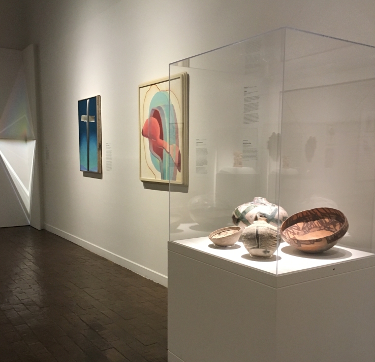
 St. Clair’s Winery and Bistro with wine flights to accompany a variety of excellent apps and main plates. All agreed that the featured selection, a Semillon, was best. Thursday we bid adieu to Tom and Renee and toured the Albuquerque Museum. Their tagline is “Art. History. People.” and the few galleries we visited included a fascinating mix of local and regional art with wonderful descriptions to give context. Yes, that’s a Georgia O’Keefe in the background.

img_0938.jpg

Today we scoot east along I-40 with our next stop planned for just east of Amarillo at Lake McClellan Campground.  Most of the rest of our stops this trip will be at first-come first-served (FCFS in the vernacular) campgrounds which is different from our usual reservation-based schedule. Given the weather and time of year we’re not concerned….

Southwestern New Mexico. Dry? No. Flat? No!

Screen Shot 2019-03-16 at 9.20.37 PMThe drive from Caballo Lake SP on Thursday, March 14, started after the wind and cold the day before, and we could see snow in the mountains on our route. Got about 100′ down Hwy 152, which we knew would be a twisty narrow road over an 8,800′ pass, when the Road Closed sign ended the debate – took the flatter southern route. From all we heard, that was a good decision. Took us along more of the scenery we’ve been used to, past a huge solar PV and wind farm, then into the hills at Silver City.

Rose Valley RV Ranch in Silver City turned out to be one of the better private RV parks we’ve been in, and our site was in a back corner with a great view behind. This was the rendezvous point to meet up with Tom (April’s brother) and his wife Renee, who rented a 30′ Class C RV for a first-time taste of the RV life and caught up with us Thursday evening. Got sites directly across from each other to start the week right.

IMG_0885Friday we drove a southern loop through Hurley where we got to experience the Old Hurley Store. Mostly a model railroad museum, Don regaled us with all the history and great stories of the silver mining and smelting town, plus a full description of their model train setup – lots of pride there.

Then on to City of Rocks State Park. This would have been a great place to camp (though for what we’re doing, better where we’re at) with sites scattered around a unique volcanic rock formation sticking up in the middle of more flat desert. Some wild wind-carved formations and lots of nesting nooks for birds.

DSCN2258DSCN2235Checked out the town of Silver City, which has a fascinating, colorful, and multi-faceted history. The most prominent feature is the Chino or Santa Rita mine, which is the longest-running and largest open pit copper mine in the country. The mountains of tailings are absolutely huge, as is the part of the massive pit visible from the road. Look very closely at the right end of the road in the photo, and the dot is a huge dump truck. While the region has seen copper, silver, gold and other metals mined in typical boom-and-bust fashion for 150+ years, the towns and countryside weren’t as run down as similar areas around the country. And the scenery is absolutely gorgeous, with mountains, rivers, woods and cliffs. One cute feature is the “Kneeling Nun“, which might take some imagination to see but is quite famous.

IMG_0893Silver City‘s current incarnation has a surprisingly vibrant arts and antiques scene, with a great museum, galleries everywhere, funky coffee shops like the one we visited twice, The Tranquil Buzz. and the Little Toad Creek Brewery and Distillery (also one in Las Cruces). We had delicious drinks and food there both days, including a great porter. Got several souvenirs including this bottle of Triple Sec Orange Liqueur. Yum.

Saturday we drove a northern loop up Hwy 15 into the Gila National Forest. There was plenty of snow remaining from a recent big dump (1-2 feet!!), which enhanced the views off both sides of the narrow ridge the road ran along for part of the way. Not a place to haul a trailer, but a great drive in the Jeep.

That brought us to the Gila Cliff Dwellings National Monument. While the dwellings are fascinating and reminiscent of what we’ve seen at Mesa Verde or Bandelier, some of the stories about what we know and don’t know of the people are particularly intriguing. Short version of one…the Mogollon People built and occupied the site during a 30-year period of extreme drought in the late 13th century, which ended with a shift to a period of the Little Ice Age. There were four migrations from the site at that time and one has been traced through DNA analysis to the Taramuhara tribe made famous in the book Born to Run. Lots more history to this place, and the cliffs and structures are amazing.

Managed to catch a cute blue jay and some rather brilliant lichen!

DSCN2260A prominent feature of Silver City which can’t go unmentioned is The Big Ditch. During an early and active boom time as the city was becoming established, they happened to put the main street in the path of annual runoff from the regular heavy rains. This caused some annoying erosion problems that became more than an annoyance on July 21, 1895, when they ended up with a 50′ deep ditch where main street used to be. A bunch of buildings were lost but those that remained started using their back entrance and main street shifted one block up. All part of what was a fascinating history of this cute town.

Today we drive in tandem with Tom and Renee to Bluewater Lake SP, west of Albuquerque. It’ll be our on-the-road routine with a fun twist!

Desert winds and great lunches

Screen Shot 2019-03-13 at 6.00.25 PM

Our drive from Guadalupe Mountains National Park to Caballo Lake State Park took us though some pretty desolate desert in both Texas and New Mexico, and around El Paso. Needless to say, there were also a few immigration checkpoints along the way. The weather system that impacted much of the country brought some crazy winds for most of the past 3 days and brought us some excitement, though fortunately our drives with the trailer Monday and (forecast) Thursday were relatively calm days.

IMG_0822We’re back in the groove of finding the best local, small, non-chain spots for lunch – 3 for 3 this week, all unique. On the drive Monday we stopped for gas and got a recommendation from the guy gassing up next to us…a Mexican place across the street, Cha-Chi’s. He suggested ordering “anything red”, and the chili relleno with tamale was spectacular.

One surprise to us on the drive north from El Paso was the number of pecan groves lining I-25, mile after mile. We think of Georgia pecans but not New Mexico pecans – now we will!

img_0823.jpg

IMG_0850IMG_0825The park we’re at is not the most scenic, particularly in the below-the-dam section we were in (none available in the main area), but served our purpose just fine. The lake is nice, particularly at the northern end with a good view from one of the bike rides.

IMG_0831My inner weather geek couldn’t resist this shot of the hills to the east of Caballo Lake, showing what happens when windy air rises over mountains and condenses. Note that the size of the cloud matches the size of the hill. Pretty cool, eh?

IMG_0828


It was laundry day on Tuesday (when you’re on the road, ya gotta fit in time for chores!) and we really wanted to check out nearby Truth or Consequences. With a name like that we’re not alone having heard of this place, and it turned out to have a vibe that didn’t match the dusty look. Turns out the name changed in 1950 when the town responded to a call from the game show to any town that would change its name in honor of the show’s 10th anniversary…so Hot Springs became Truth or Consequences. And though the main attraction over the decades has been the namesake hot springs, we didn’t indulge. We did indulge in a couple of lattes and a delish vanilla scone at The Passion Pie Cafe, with a storefront that is a great example of the funk that’s scattered throughout the town.

Next up was a visit to the Geronimo Springs Museum, a wonderful trove of local history with equal parts early rancher/cowboy life and stories of the Apache, including several fascinating exhibits on Geronimo, a barbed wire collection, cowboy had collection, arrowhead collection and much more.

With clothes folded, lunch was at a recommendation from the museum staff, Latitude 33. I screwed up and didn’t take a single picture so you’ve got to click the link on this one. In a small dusty desert town how often do you get Asian fusion cuisine that could rival anything we’ve had elsewhere?? April had the Vegan Korean Glass Noodles bowl (sweet potato noodles!) and mine was the Spicy Peanut Noodles bowl. Huge portions and incredible flavor.

Wednesday we took a road trip to White Sands National Monument, famous for the 275 square miles of brilliant white gypsum sand dunes, and the test range that includes Trinity Site where the first atomic bomb was detonated on July 16, 1945. The area is also known for its blustery winds, and we got to experience winds that were more than blustery. These winds got the best of me when I got out at the San Augustin Pass to take a picture of the dust storms in the valley. The wind was probably blowing about 60 mph directly behind us, yanked the door from my hand and slammed it forward with two dents in the door as souvenirs. Ugh. The door works fine so no problem, just some body work when we get home.

With the winds blowing we were unable to take any hikes across the dunes but we did get plenty of incredible scenes showing how the place is constantly changing.

After driving the near-whiteout of a gypsum dust blizzard we headed further northeast to Alamagordo in search of a bbq place April found online. Driving up to the building we literally checked the side to be sure this entrance was the place with such favorable reviews. Turned out to be another of those rough-looking, great-tasting gems. The green chili pinto bean bowls were incredible – mine with brisket and April’s with pulled pork. Yum.

Screen Shot 2019-03-13 at 6.07.34 PM

Today we head to Silver City which was under a Winter Storm Warning the past couple days to meet up with Tom and Renee, April’s brother and his wife. They’re renting an RV for a first-time experience and we’ll be with them about a week. FUN!

Island Hopping in West Texas, plus a cave

Screen Shot 2019-03-09 at 7.49.05 PM.pngLeaving Terlingua (Big Bend) we headed north on typical Texas secondary highways: lots of wide open prairie, straight roads, hills, and a whole bunch of empty land – with some gas and oil wells to remind you where you are. Stopped for a much-needed car/trailer wash and groceries in Alpine, which was about the only town of any size between Big Bend and Davis Mountains SP.IMG_0783

Fort Davis is yet another spot with a fascinating history, in addition to being the town with the highest elevation in Texas. Got a bunch of fun facts from a ranger talk at the park – we’ve gotten to love those ranger talks. After mostly pushing out the Comanche, Fort Davis was one of the stops for the first mail delivery and after the Civil War became an important crossroads town. Davis Mountains SP has its own story, where wealthy landowners lobbied the legislature to establish a park. That was finally approved in 1933 and became a major construction project for the CCC, including beautiful adobe-style Indian Lodge (only lodge in the Texas State Parks system), a Skyline Drive in the park, and various park features. It was at the ranger talk we also learned about “Sky Islands“, which are areas with mountains surrounded by dry plains, where the higher altitude creates its own ecosystem with cooler weather and greater moisture. Turns out Big Bend, Davis Mountains and our next stop at The Guadalupe Mountains are all Sky Islands!


IMG_0794IMG_0819Next stop was several days at Guadalupe Mountains National Park and one of our rare stays at a “First Come First Serve” (FCFS in the vernacular) campground. We were a bit anxious; Friday was the start of Texas public schools spring break and only 19 RV sites in what was described as a parking lot. Not to worry – yes, it’s a parking lot but there were several options when we arrived at mid-day and we snagged a site with an incredible view and the “parking lot” turns out to be the trail head for some great hikes.

Hit the trail Friday afternoon, Devils Hall Trail which turned out to be a spectacular 4.2 mile trek with some rather interesting rock scrambles up the dry wash bed. It led to the namesake feature, Devil’s Hall, a narrow passage between towering cliffs on both sides.


Attended an evening talk about predators in the park such as rattlesnakes, mountain lions and all the others. The ranger told a great story where they were in the Visitor Center on a slow day and saw a woman outside looking at something. She came in and complimented them on their fascinating electronic moving snake exhibit near the entrance. Well….when they told her they don’t have an electronic snake you can imagine her expression. She had been following the bobbing head of a rattler with her finger, trying to touch its flicking tongue! The point from the ranger’s story was that rattlers aren’t particularly interested in biting people, but I can imagine what that woman thought after she learned what she’d been doing!

Then the forecast high winds and a 20% chance of rain hit. Those familiar with travel trailers will appreciate this. The wind was reported to be at 25-40 mph with gusts over 50 mph, though there were probably some stronger and we had minimal wind break from shrubs. By morning the wheel chocks were all blown loose and at one of the stabilizer jacks, the plastic spacers were also blown away leaving that corner hanging. Found all this when we got up, so learned some lessons. Oh, and it was blowing rain the entire night. Exciting stuff!

Saturday brought a crystal clear morning and a guided hike up McKittrick Canyon to the Pratt Cabin then on our own to The Grotto then to The Notch, total of about 9.4 miles. One of those, “Hey, should we go on to the next cool thing?” days…all different and all amazing. Our guide was remarkably knowledgeable about the history, flora and fauna of the park and wonderfully enthusiastic – which compelled us to see the other sights up the trail. Nice.


One of the many fun facts our guide talked about was the common Agave Americana, also called the Century Plant because of the long time before it flowers, usually 10-25 years. FYI, the agave is closely related to the lily and is not a cactus. A possible record is the agave at the Univ of Michigan that took 80 years to flower!! This picture shows the agave next to the other very-common sotol yucca.

DSCN2165

DSCN2168

Wallace Pratt was the first geologist employed by an oil company (Humble Oil) and ended up falling in love with the yet-undeveloped (post-Mescalero Apache) land of the Guadalupe Mountains. Good at his job (~95% success rate finding viable well sites), in 1921 at age 36 he purchased most of McKittrick Canyon with partners who he bought out after the Depression hit. Built a family vacation cabin out of stone with a stone – not just slate but stone – roof (a geologist, after all). Very cool stories about their lives there.

DSCN2170From the cabin, the trail continues up the wash to a geologic feature aptly called The Grotto. Fun story about the wash: On our hike to Pratt Cabin we crossed 7 times, twice over water – the same water that dips below and rises above the surface as it flows out of the canyon. Prior to some major flooding in 1943 and 1968, there was more water flowing and the travertine rock formed dams with waterfalls. Not any more!

Then it was on and up to The Notch, which our guide had described as similar to stepping through the doorway in The Lion, The Witch and The Wardrobe. As we found out, a very good description. The video shows a 180 deg view from the other side of The Notch, the photo shows the valley we climbed up from. Amazing.


DSCN2182Sunday we headed to the more famous National Park near here, Carlsbad Caverns. On the drive in, saw a coyote cross in front of us and into the desert. So glad we got there early to enjoy part of the walk in near-silence, which is the way the caves should be explored. The spring break and weekend crowds came and it was completely packed when we left around noon. This place is breathtaking. We’ve been in many caves and all have their special features – Carlsbad has so many and is so huge. We took the Natural Entrance Trail to the Big Room Trail for a total of about 2 1/2 miles. Think about that. And Notre Dame Cathedral can fit inside The Big Room. Of course none of my pictures do justice to the place. (And we didn’t stick around to see the bats fly out – must be another facet of its amazingness…)

DSCN2213

This shot looks a bit boring compared to the others but has a story. Turns out one of the many byproducts during limestone cave formation is gypsum. This is a chunk about 15′ thick that includes the characteristic long holes that have been drilled through it by dripping water.

Today we move on, through El Paso to Caballo Lake State Park, between Truth or Consequences and Las Cruces, NM.

Big Bend II – so much more!

One of the goals for this trip was to return to Big Bend National Park at a time when it wasn’t like a blast furnace as it was on our first visit about two years ago. Well, wouldn’t ya know we’d get here in time for some crazy temperature swings. Arrived on a gorgeous warm afternoon Sunday, March 3, followed by a nighttime temperature drop from 88F to 38F! Not too hot this time.

DSCN2101Driving into the park Sunday we were greeted by the bluebonnets (aka lupine) in bloom along the road and off into the hills. Tried to capture this in a photo but it’s an incredible sight. We timed this trip right for many desert flowers…I’ll post the other flower pix at the end.

Monday we heeded a ranger’s advice based on the weather and headed to the Ross Maxwell Scenic Drive, a repeat loop from last trip with mostly-different stops along the way. Along Ross Maxwell, stopped again at the Sam Nail Ranch with two original windmills – one still pumping water. Our long hike of the day was to Mule Ears Spring, which is a remarkable flowing spring in the middle of the dry desert. Amazing to see the remnants of homesteads from when ranchers lived here. The peaks that form the Mule Ears are spectacularly distinctive and aptly named!

After a stop at the Castolon Visitor Center in a barracks outpost built in 1920, met up with the Rio Grande near Cottonwood campground, which could be an option for a future visit. One of the most spectacular and short hikes was into Santa Elena Canyon, a very narrow canyon along the Rio Grande with some (reportedly) crazy rapids. Beautiful trail into the gorge as far as you can walk.

Drove back on the Old Maverick Road, which is all dirt and rather exciting.

DSCN2123Tuesday was a bit warmer and not as cloudy, and we decided to head to the nearby Big Bend Ranch State Park, biggest in Texas so you know it’s big. Saw some brilliant bluebonnets at the visitor center then headed west along FM170 which parallels the not-so-grand Rio Grande, stopping at the very cool Closed Canyon Trail that is every bit a slot canyon and one where we were able to take the doggies. Wouldn’t want to be in there in the monsoon season…

DSCN2126.JPG
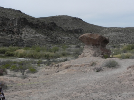
After a short walk at some amazing hoodoos, we headed back east to the big hike of the day at West Contrabando, along the Fresno Divide Trail, Dome Trail and West Main Trail. This ended up as an ambitious 8.7 mile loop through some incredible scenery: flat desert scrub, hilly and “gorge-ous”. Took us to a viewpoint of El Solitario, which is “THE signature landscape feature” of the park, a collapsed volcanic dome. Tough to visualize from ground level, but there is plenty of fascinating geology everywhere. Also some fascinating history, such as the remnants of what was an active cinnabar (ore containing mercury) mine – which was the boom industry in the region from about 1910-50. Areas of artifacts (old sardine can) and ruins from what was a tough existence.

Wednesday we headed back into Big Bend NP and the Chisos Basin area which we hadn’t seen before. Amazing how one park, albeit a big one, can have so much variety in terrain and climate. Took a 5.5 mile hike on The Window Trail, an impressive trail built by the CCC in the early ‘40’s. Lots of stone steps built into the stream bed. Started off by seeing a couple of deer walking near the lodge – an auspicious sign for some great views to come. The trail continues along the valley then picks up water at a spring about 2/3 of the way to the point where it flows over the edge through a narrow channel. The Window.

And here are the flower (and a scrub jay) pictures…only some of the amazing variety which we were fortunate enough to catch.

Next stops: Davis Mountains State Park and the Pine Springs Campground in Guadalupe Mountains National Park, both in far West Texas.

Lastly, a sunrise shot from one of my daily runs with the doggies along a backroad next to our site at Big Bend Resort & Adventures.

IMG_0781


More Texas Surprises

Headed out of the fog and mist of Port Aransas on Friday, March 1st, northwest through more fog and mist. Then the weather cleared, the terrain changed and we arrived at Garner State Park about 80 miles west of San Antonio. Turned out our lunch stop was another fabulous find by April….and a repeat of where we stopped almost two years ago. Scroll down if you like to the post of May 15, 2017, and you’ll see me raving about Heavy’s BBQ in Hondo, Texas – and it is still that good. Too funny and too much fun we ended up at the same spot. The brisket and house-made sausage were every bit as good as last time…two meals worth.

After miles and miles of oil wells and petro-infrastructure industry across some pretty flat country, it was a wonderful transition to some gorgeous hills along the Rio Frio river valley. After setting up, we took full advantage of a break in the weather with a nice bike ride through Garner State Park, some fun bird watching at a cute and well-kempt bird blind and a great view of the river.

IMG_0749

And a shot of the misty morning with a common sight – balls of mistletoe in the trees!

Before leaving Raleigh, we had new tires put on both the trailer and Jeep, and it took us all of two weeks to pick up two nails in one of the trailer tires. Discovered this as we were setting up at our spacious site but had zero cell/WiFi service and too late to drive to the nearest town. So….along comes a wonderful park ranger who let me use his phone, I called Coach-Net (a AAA for RVers) and by bedtime a repair truck had come and patched both holes. Problem solved!

IMG_0750IMG_0765Two waypoint stops at Texas State Parks have added to the growing list of great experiences. Wished we could have stayed at Garner SP longer! The drive took us into more rolling hills and our next stop – Seminole Canyon SP – was a repeat from our first trip. Got a fantastic site this time, in the far corner of the campground with a 220 deg view of the open bushy terrain between us and Mexico. Took an 8-mile walk with the pups on the Canyon Rim Trail with some incredible views of Seminole Canyon and the steep rock walls along the Rio Grande. Parts look similar to the glacier-carved valleys we saw 1500 miles to the north, but obviously not glacial! The desert flowers are blooming everywhere, including many tall Torrey Yucca as in this picture. Beautiful to see them poking above the brush.

Our next stop on Sunday, March 3, was Big Bend National Park, another repeat from our first trip. Stopped for a few sundries in Marathon, one of the large number of tiny Texas (and other states) towns that time has forgotten. But wait, in a converted Gulf gas station on a dusty corner is a sign for a brewery and bbq. What’s this?? Stumbled on some of the best brisket (yep, maybe better than Heavy’s in Hondo) and a full-bodied in-house stout at Brick Vault Brewery and Barbecue. Note the house-made pickled onion garnish…and that’s jalapeño mac-and-cheese. Yum.

IMG_0769

Then into and through the park to our site at Big Bend Resort and Adventures in Terlingua. Greeted by the same incredible scenery we remembered from last time, and more strange weather: temps that dropped from about 87F on Sunday to about 37F Monday morning. More on our time at Big Bend in the next post!

The Texas Gulf Coast

Weather is weather, but 12 days into our latest trek and we have yet to wear sunscreen or put on sunglasses. (And I’ve been very good about sunscreen, after a firm and appropriate lecture from my dermatologist cousin Carley on our first stop of our first trip!) Enough whining. Traveled from the swamps and bayous of Lake Fausse Pointe SP west of New Orleans to League City near Houston with yet another first-time culinary experience at lunch.

Screen Shot 2019-02-27 at 6.30.26 PM

img_0645.jpgIMG_0646It’s so much fun how many regional foods there are, and I’ll try them all. Never heard of boudin much less boudin balls, but started seeing many billboards for the best-of-boudin as we rolled through western Louisiana and east Texas on I-10. April found Mutt and Jeff’s in Vidor, Texas and I had to order their boudin balls with my salad. Rice, burger meat (apparently the purist would make them with pork sausage) and spices. Fried. Yum.

IMG_0648Crossed over the gorgeous Fred Hartman Bridge at Baytown near Houston to get to April’s brother and wife, Tom and Renee in League City (southeast of Houston), where we parked for three nights. Had all sorts of fun including the Battleship Texas, the museum and monument at the San Jacinto Museum of History, a walk in the Armand Bayou Nature Center, and an afternoon at the Houston Museum of Natural Science. So much cool stuff…did you know the San Jacinto Monument is 13′ taller than the Washington Monument? Happenstance? I don’t think so! And some basic Texas history that (partly) explains Lone Star State pride: the only state – not a portion of a state – that was its own country, from 1836-46.


IMG_0657
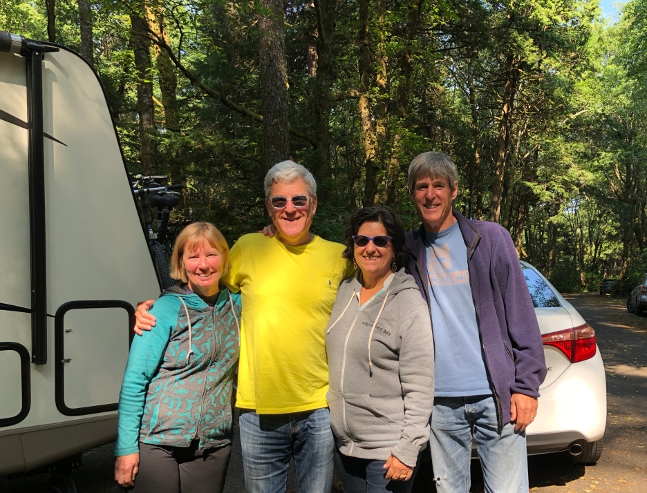
Best of all, of course, was simply spending time with Tom and Renee – we’ll be seeing them again in a couple of weeks when they rent an RV and join us for a week near Albuquerque…stay tuned!

Had a fabulous dinner at Marais in League City – the Lump Crab and Shrimp Tower was spectacular, as was everything else. And the four doggies got along famously – not so much with their cats.


IMG_0715Then it was off to Port Aransas on Mustang Island, which is just north of the better known Padre Island – which (here comes another factoid for home trivia games) is the world’s longest barrier island. The drive that day was filled with adventure, including a back-track detour for an accident (very nice cop: “There are chemicals all over the road!”) which brought us past this cool building in Bay City.

IMG_0717

Screen Shot 2019-02-28 at 11.56.58 AMApril found another interesting lunch spot, this time far off the sparsely-traveled Hwy 35. Fishville Trading Post had a full menu with some surprisingly good food given the location. Not another soul there so we got lots of very friendly attention from the staff.

Almost there, we’re blindly following Google Maps and things aren’t making sense with time and distance…turns out the highway includes a short ferry ride into town. Fun – and a very efficient operation. As we drive up to the ferry landing, shrouded in low clouds and fog are three huge oil rigs (or whatever) that looked just like some imperial starship. Impressive.

IMG_0725 2In keeping with our Gulf Coast weather experience, most of the three days in Port Aransas have been foggy and cool with some light rain mixed in, perfect for reading and catching up. The place we stayed is called On the Beach and it is. The broad beach includes a beachside road and RV parking, which would have been an interesting alternative as a place to park.  One afternoon at the South Texas Botanical Garden in Corpus Christi gave us our first few sunny hours, some nice walks and a bunch of exotic macaw-type birds in big cages. The dogs (mostly Enzo) didn’t quite know what to think, but one bird would let out an ear-splitting squawk that set off the rest of them. Hilarious. As with everywhere else in the area, still lots of damage from Harvey in 2017 with some – but not all – in various stages of repair.

Today we head inland – Garner State Park due west of San Antonio on the “cool, clear Frio River”.

“The Mad Potter”, Jazz, Tabasco

Screen Shot 2019-02-23 at 8.22.35 PM

IMG_0606April, as a former hobby potter, wanted to stop in Biloxi to see the Ohr-O’Keefe Museum of Art – so we did. Fascinating history of the epitome of a true character, Ohr brought all sorts of attention to Biloxi in the late 19th and early 20th century but his artistic style wasn’t fully discovered until the ’60’s. It then became world-renowned, and still is. The museum is (obviously) a unique architectural creation of Frank Gehry with construction started right on the Gulf just before Katrina wiped out much of Biloxi in 2005. All those empty lots you see in the picture were houses, and that goes on for miles along the beach.

IMG_0604

IMG_0616We shifted our plans to rendezvous for a night with close friends Ron and Cathy who have been full-timers in their 40’ motorhome for 20+ years. Stayed next to them at the same Bayou-Segnette SP we had been at 2 years ago. Ron grew up in NOLA and his grandfather was one of those story-book icons who would dress in his white suit and dine – with family all around – at Galatoire’s, itself one of the old-time New Orleans traditions. So we had our Sazarac cocktails, oyster Rockefeller, etc. with a Tabasco-and-powdered sugar dipping sauce as part of what was a full-blown New Orleans feast. (Dumb mistake to not get a picture with the 4 of us, or of our site next to theirs!)

Before dinner we visited the New Orleans Jazz Museum which is in the original NO Mint – the only mint to have changed owners 3 times, and that was within a couple of years. Best part, of course, is the exhibits about various jazz greats including a room dedicated to Professor Longhair. Quirky? Yes, but that’s the point. Also walked the streets a bit savoring the sights…

On the way from NOLA we stopped for lunch at a classic roadside restaurant adjoining a small-time casino, Sam’s Southern Eatery where we both had shrimp, fried and a salad. Turns out this is a chain, though I never would’ve guessed based on how it looked!

IMG_0624Google then took us on a pretty crazy route to Lake Fausse Pointe SP through some backroads to a levee (in the background of this picture). That’s when we came up to a narrow one-lane bridge with many warning signs, turned around and retraced our steps to a longer route into the entrance. Thank you, Google!

DSCN2076The park was pretty much in the middle of nowhere in bayou-country Louisiana (which, of course, is much of southern LA) and with all the rain it’s wetter than usual. Had a great run on a barely-open flooded trail where most of my aerobics was from watching out for snakes and gators (heard a big one just to my right splash into the river). Note the raccoon in the water – I’ve never seen that before, and it stayed so still the dogs never noticed.

Then it was on to the Tabasco factory tour and museum at Avery Island. I love Tabasco, but will never look at a bottle again without admiring the family history it represents. Did you know they follow the same process, storing the pepper/vinegar mash in oak barrels, with salt as the top cover, for 3 years before bottling? And did you know Avery Island is a salt dome which gives it some much-needed elevation but also some unusual areas for wildlife. One of the long line of McIlhenny’s started a preserve on a big chunk of the property called Jungle Gardens with numerous features including a Camellia grove, Sunken Garden, “Bird City” (which helped bring back the near-extinct snowy egret), etc.

With no WiFi the past few days, this is being posted after we’ve arrived at our next stop, League City near Houston where we’ll park at Tom and Renee’s. Then it’s on to South Texas!

Montgomery, AL: Everyone should visit.

This post doesn’t have a lot of pretty pictures of scenery or gorgeous nature shots. If you want that, I’ve got a bunch in Dropbox herehere and here from our recent special-occasion trip to Tanzania. This is more about social justice issues – which, when you really think about it, are not political. Those who have been following our wanderings may remember first-time visits last year to the Canadian Museum for Human Rights in Winnipeg and the African American Museum in DC. Both times we were blown away with how well these complex and sobering issues were presented.IMG_1695

The drive from near Greenville, SC, to Gunter Hill Park near Montgomery followed I-85 straight through downtown Atlanta, with no good options for a less crazy route. And it was rather crazy-normal traffic which I’ve experienced many times in a car but first time hauling a (albeit, relatively small) trailer. A fun challenge and all went well.

For all of us geography-challenged types, here’s the map.

Screen Shot 2019-02-18 at 4.43.16 PMDSCN2055

Montgomery is, like many other capital cities, about in the center of the state and has the surrounding natural beauty of, well, most anywhere. It also has a history, some I was aware of and much I wasn’t. The “domestic slave trade” that exploded following abolition of the importation of slaves in 1808 built Montgomery to be the center for slave auctions. (The fountain is in a central square (note the capital building in the far background, lower right) that was the primary slave market.) Rosa Parks and the Montgomery bus boycott of 1955-56 are just a couple key events, and the opening of The Legacy Museum and associated National Memorial for Peace and Justice has to be right up there for impact. The focus is on racial lynchings in America – 4,400 documented and many, many more undocumented between 1877 and 1950. This was not just a problem in the south – Minnesota and New York are on the list – and was part of what can be called a continuation of race-based slavery – in principle if not in fact.

DSCN2052

Everyone should learn more about this history that has been systematically buried too long. Many issues in current events would be non-issues if there was broader understanding of the realities of history. Check out some of the links above, read this editorial about the museum and visit Montgomery if you can.

(It’s not all heavy and sobering, of course. Had an absolutely spectacular lunch at the “Locally Owned, Regionally Sourced” Central Restaurant, with a club sandwich made from bacon, pimento cheese and fried bologna accompanied by the best french fries ever. And April’s grilled chicken salad had a unique, light dressing that was also the best ever. Eaten before I could get pictures.)IMG_0599

Our campsite is on a huge creek called Gun Island Chute that runs into the Alabama River within sight of the park. Spacious, long, level concrete pads long enough at many of them to park 5 of our rigs. Lots of woods that is all bare trees now and long roadways that are great for biking and running. Not sure when, but it’d be a great place to spend more time just chillin’.

Today it’s off to Biloxi – not to gamble, as everyone assumes…!

Another (shorter) adventure begins…

It’s been just over four months since we returned to Raleigh and time for another TT (aka, travel trailer) trip around the country. Left yesterday morning in a cold rain – an appropriate sendoff for this trip to southern Texas and New Mexico, with many stops to and fro. Some of the places on our itinerary (always subject to change, of course!) are the National Memorial for Peace and Justice in Montgomery, the Tabasco factory, Tom & Renee (April’s brother and his wife), Corpus Christi, Big Bend NP, Carlsbad Caverns, the Albuquerque area, sandhill cranes in Nebraska, etc., etc. Stay tuned!

Our first day had most everything we’ve come to love (or expect) on the driving days during our treks – and a few first-time events. Rain, sun, traffic, open road, a major tractor trailer blowout in front of us in a construction zone (never dangerous but scary), a few nice views (this ain’t the Rockies, ya know), and yet another fantastic small-town lunch spot. Stopped in Belmont, NC, home of Belmont Abbey College and one of the best combination bottle shop, wine store and funky restaurant we’ve ever seen, The String Bean. Note the cooler in the background with a bunch of ciders, bourbon barrel beers, you name it – with more coolers and beer/wine shelving throughout the place. Turns out there’s a lot to see and do in Belmont so maybe we’ll be back!

IMG_0590

IMG_0591Another 90 minutes got us to our first overnight site, at Ivy Acres RV Park just past Greenville along I-85. Since it’s still late winter and a bit chilly we can only imagine what it might look like leafed out. Nice pond, lots of trees and a bonus effect of a herd of mooing cows a couple hundred yards away. Friendly neighbors on both sides made this 18 hour visit even better…but now it’s on to Montgomery, Alabama and warmer temps.

12,344 miles, 95 days, 19 states, 5 provinces

IMG_0005This is the wrap-up post for our 3rd trip (not including one short initial trip) and our 2nd that lasted about 3 months. That seems to be, at this point, a good length of time for us, allowing cross-country travel with the ability to see and experience a lot. Our pace is not for everyone but fits us well. We rarely felt that the time spent at each stop was too rushed and it was never boring. Most legs of the trip were covered with fun anticipation about the next destination. And those legs that were mere stopovers frequently brought fun discoveries – on top of all the surprising, fascinating, and delicious lunch stops!

We’ve observed that the RV culture is in some ways an interesting reflection of the country (and in other ways, definitely not a reflection of the country!). Depending on where we were and the timing (weekend vs mid-week, summer vs. early fall, etc.), fellow campers might be cute families with active little kids that fawn over our doggies, loner guys (very few women) who certainly have a story but aren’t sending “let’s meet!” signals, some larger groups (seemingly linked by family, culture or friendships), many retired couples of various ages and stages, younger couples who mostly looked ready to conquer the next adventure, etc. We could have reached out more, but it’s also interesting how private most people are. It’s a very rare day that anyone initiated a conversation with us, even though we’re usually within 20′ of neighbors on at least 3 sides. Most everyone is friendly, few are looking to share stories. Kind of like many neighborhoods.

Our 2014 diesel Jeep continues to impress us with its reliability and performance. Of its 80,000 miles, probably a quarter of those are towing the 5,000 lb. trailer, with some pretty abusive conditions: altitude, steep and long hills, high temps. The only problems we’ve had were all preventable and all have happened at times and places that didn’t cause much disruption in our travels. Lucky, and a bit amazing.

Are we happy living in our 18′ box week after week with each other and two energetic black lab mutts? That has also worked out very well. Very few issues or complaints about the design or layout of the trailer although, like any “house” there are always projects to maintain or upgrade the place. We prefer camping in woodsy sites with great views but also have come to realize we do like electric and water hookups if it’s going to be more than a couple of nights (partly due to inherent limitations of our rig). The generator we hauled everywhere was definitely worth it for those few times we were boondocking (no hookups) and April had a sewing project to work on. All part of keeping things relaxed and home-like.

IMG_0004Where to next? It was fun pasting states onto our map as we traversed the country – that goal guided our routing decisions several times this trip – so finishing out the Lower 48 is on our minds. We’ve got 14 states to go and most of those are in the Northeast. We missed Oregon this time. We shortchanged ourselves visiting Colorado and the heat chased us out of the desert Southwest on last year’s trip . And there are endless options to return to gorgeous scenery in regions we’ve been in or near. Frank Lloyd Wright houses are everywhere and that’s been a bit of a theme. We’ve also looked at how many National Parks we’ve visited and thought about working through the full list. So many options, so little time….!

We haven’t fully blocked out our plans for next year so not sure when the next post will go out, but if you’d like to tune in next time simply click the Follow button. From all I’ve heard and seen, WordPress is very good about not using your email address for anything, and I’m definitely not going to spam you. Comments are always appreciated – it still feels weird and a bit arrogant of me to blindly send these out. This is a good way for me to journal our trips for friends and family, and I hope you’ve enjoyed coming along for the ride.

Until next time…enjoy!!

-Jack and April

NOVA and DC

This is our last stop, relatively close to home in familiar territory but still full of surprises. The campground is in Northern Virginia (NOVA) about 5 miles east of I-95 and 20 minutes from Heather and Felipe’s condo in Alexandria but on a big bay in quiet woods off what could easily be mistaken for a rustic rural road. The first few days were misty, rainy, dark and damp but then the sun came out. Took short walks and long runs in the woods – the park is probably packed in the summertime but pretty quiet for our stay.

IMG_4353
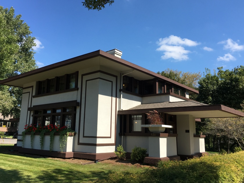
Besides plenty of fun (but never enough!) visiting with Heather, Felipe and friends Javi and Camila, our DC touristing stops included the newish National Museum of African American History and Culture on The National Mall, and George Mason’s Gunston Hall which we could walk to from our campsite. We fit in a couple of off-the-beaten-track museums, also very interesting, at the Freer Sackler Gallery and the nearby National Museum of African Art.

IMG_4351You might have heard how spectacular the relatively-new African American Museum is, but it’s better than that. Worth a special trip, and worth carving out at least a half-day to see, even better two half-days. To us, it was a combination of enlightening, disheartening, uplifting and educational – which is probably the intent. Many exhibits were a celebration of the contributions of black Americans throughout our history with, not surprisingly, some little-known biggies. We ended up going three times for a few hours at time and didn’t spend enough time.

A short trail from our site at Pohick Bay Campground led to a long, majestic, tree-lined driveway entrance to George Mason’s Gunston Hall. Mason was one of three delegates to the highly contentious (sound familiar?) Constitutional Convention who didn’t sign the final version of the Constitution. He was a private guy, but this caused his neighbors and friends like Washington and Jefferson to stop speaking with him. He wrote a list of his 16 objections which Washington asked to be published so he could publicly refute them, Mason’s basic concern being the division of federal vs. state authority (and lots more). Fascinating. Equally interesting is the design and preservation of his house and grounds. Note the intricate woodwork that was everywhere in part of the lower level used for entertaining – it’s all wood carving, done by an indentured servant.

Our last full day of our trip was a full day: Visits to the Freer Sackler Gallery, National Museum of African Art, back to the African American museum, cheering Heather, Felipe and Camila on to a 2-1 win at their soccer game (Felipe scored one and Camila had a strong assist on the other), an unexpected visit with Lauren and Seth in town for a wedding and beers and dinner at Oktoberfest at Port City Brewing (first production brewery in Alexandria since Prohibition!). Phew!

Then I noticed a nail in one of the Jeep tires.

Got the tire fixed Sunday morning and will be on the way by noon, heading to home in Raleigh. One more summary post later this week and that’ll be it for now. Fun trip!!!

Virginia!

IMG_4292

If you’ve been following along, you might have noticed that we’ve had almost zero rain for the past 3 months. Appropriate, I suppose, that as we near the end of this journey it’s been mist, drizzle and rain starting in West Virginia and continuing off and on for days. The low and patchy clouds made for a beautiful drive over the mountains between WV and Virginia on Sunday, September 23, and the weather didn’t get in the way of some very interesting exploring.

IMG_4306

Nelson151_Rack_Back_2018Found an RV Park between Staunton and Charlottesville, VA, not too far west of the Skyline Drive (aka Blue Ridge Parkway in NC) and still in hill country. Lucked into one of the best sites about 20′ from a babbling brook, flowing nicely with all the light rain (visible in left background of that photo). Sunday, after setting up, we headed out in search of a brewery or cidery and stumbled on an interesting local attraction: Nelson 151. Turns out this is a stretch of about 15 miles with 6 wineries, 3 craft breweries, 2 craft cideries and a craft distillery. No, we didn’t stop at every one but it was a pretty cool find. Stopped in at Blue Mountain Distillery, tasted and bought some craft gin at Siverback, and tasted and bought some pretty unique ciders at Bold Rock – yes, the same Bold Rock that’s everywhere in stores.IMG_4294

Monday, after a last round of blueberry pancakes (finishing up our supplies!), we headed to Staunton for a visit to the Woodrow Wilson Presidential Library and Museum. Wilson served two terms from 1913-1921, and dealt with major social, cultural and economic upheavals – including, of course, the USA’s late entry into WW-I. He dealt with issues of race (himself a segregationist), the Suffragette movement, established the income tax and Federal Reserve system, and passed child labor laws, to name just a few. Very interesting how much impact he had on US history but he’s not at the top of most people’s “notable presidents” list.

IMG_4298

Even more interesting and surprising was our afternoon at the nearby Frontier Cultural Museum. It was nice there was almost nobody else there – it’s clear they have a lot of school field trip visitors – but this was one of the most fascinating exhibits of early American life we’ve seen. They’ve brought homesites directly from the locations of those who came to this region: an Igbo compound from West Africa, an English farmhouse, an “Ulster Scottish” farmhouse, German farmhouse, several examples from nearby 19th century farms, and a Native American compound. Each had an interpreter who was both knowledgeable and passionate about the history related to each exhibit. We ended up running out of time, learning so much from each stop. (The geese are named Beatrice and Benedict and have adopted the duck. 18th century bread recipe: one bottle beer, equal amount of water, some sugar and enough flour to make the dough. (There really was more serious history we heard about….) 🙂

Tuesday we headed to Charlottesville with our first stop at another pleasant surprise: the Kluge-Ruhe Aboriginal Art Museum. Who would expect a small but world-class collection of Australian Aboriginal art in the hills of Virginia? Very cool.

IMG_4307

Then lunch and a smooth milk stout at one of the five breweries in little Charlottesville, Three Notch’d Brewing. Even this place has a connection with history: a moonlit ride by Jack Jouett down Three Notch’d Road to warn many of Virginia’s leaders to escape imminent capture by the Brits. Any town and region with as much history and as many craft everythings as this region, is worth a visit.

Last stop was Highland, the country plantation home of the fifth President, James Monroe. This is adjacent to Thomas Jefferson’s Monticello and very near the home of James Madison. Another great bar-trivia factoid: Monroe was the only President after Washington to run unopposed in an election! Monroe died on July 4th, one of three of our first five presidents to die on July 4th…coincidence?? Sorry for the underexposed shots of the buildings…the big tree is 300 years old, so was about 100 years old when Monroe built his house there. Cool, huh?

Today we head to our last stop, Pohick Bay Regional Park which is southeast of DC and about 30 minutes from Heather and Felipe’s in Alexandria. Last stop on our 2018 trek!

word association: …West Virginia.

IMG_4262
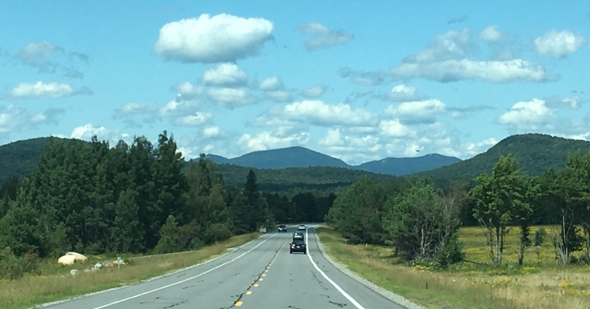
So what did you think of first after reading that title? Maybe coal mining, gorgeous steep hills interlaced with rushing rivers and streams? That pretty much sums up our two days here. The drive from Kentucky hill country to WV hill country was, well, hilly and beautiful. Passed through more white-fenced horse farms but mostly up and down the woodsy hills.

We are definitely past the vacation season, and Little Beaver State Park was mostly empty, even over the weekend (the rainy forecast was certainly another factor). Got a wonderful site with a woodsy view, dead quiet and dark at night (it’s not always that way!). Nice.


The park itself has many miles of trails and a gorgeous lake with and interesting dam. Too bad the rain chased us out before we could check out the trails other than some morning runs with the doggies.

DSCN0684

April picked this spot to put us close to the New River Gorge National Park, which was our first visit on day one, Friday, Sept 21. You might have heard of the New River Gorge Bridge, which is the longest steel span in the western hemisphere and third highest in the US. If this sounds familiar, it’s probably because of their annual Bridge Day where nut-cases tempt death by BASE jumping off the span (one every 30 seconds). Talking to one of the rangers, yes, there have been fatalities but we won’t go into the details. They banned bungee-jumping a few years ago for some strange reason – who in their right mind would ever bungee-jump off a high bridge over a river??? (Evan, don’t answer that.) The bridge itself really is a work of art, and the gorge is, well, gorgeous.

Saturday we ended up on a bit of a detour through some very back-country roads (ask April what she thought of that drive…no, don’t ask) to Hinton on the New River, then upriver with some nice views of Sandstone Falls, one of the more treacherous sections along what is known as a whitewater-lovers dream.

Next came our visit to the Beckley Exhibition Coal Mine. This is coal country after all, and the history of mining is fascinating from so many perspectives: the technology, the process, the worker exploitation (“company store”), the social structure, and more. No way could I have survived crawling through a 30″ seam to chip out 5 tons per day, but that’s what they did. According to Marvin, our tour guide who was a miner in the area for 27 years, this mine was active from 1890 to 1910, dormant 50 years then resurrected as a tourist site in the ’60’s. The tour was fascinating – riding behind what looked like an original tug 1500 feet through the area that was originally mined then widened for tours.

Today we head to one of two parks between Staunton and Charlottesville – we’ll decide while on the road. A lot easier to be spontaneous during the off-season!

Lexington, Kentucky: more than horses and bourbon!

IMG_4258Stayed two nights at Fort Boonesborough State Park along the Kentucky River. The park includes a re-creation of the Fort complete with period actors, a swimming pool, mini-golf and numerous other sights but we saved those for next visit. Driving here took us from Louisville (home of the Kentucky Derby), to Lexington (home of the Univ of Kentucky), and through some gorgeous horse country with rolling hills and long white fences. Missed getting a good picture, but it was a spectacular drive on a sunny day.

IMG_4261We’ve visited nearby Berea before and this art-centric town was one of two main reasons for picking this area to stay in. Our last visit was maybe 22 years ago when Lauren and Heather were heavily into Breyer Horses and we combined a trip to the horse museum with a visit to the town’s galleries and studios. This time, it was galleries and studios, and bourbon. Different times and different priorities, eh? We were sorry to see a number of empty commercial spaces, but there are still many incredible artists in the area. This is a college town, with Berea College a prominent influence – and the college has a fascinating history. A highly-ranked liberal arts school, it’s one of few to provide free tuition (work-study, etc.), and the first in the country (founded 1855) to be co-ed and racially integrated. Some timely history: In 1904, Berea was forced to segregate by a law passed in the Kentucky Legislature. They took the issue to the US Supreme Court, lost but re-integrated as soon as the law was amended in 1950.

On recommendation from one of the art-potters, we had a spectacular lunch at The Native Bagel Company. Yep, bagels in Berea – who woulda thunk. Then it was off in search of the perfect bourbon (that’s a joke….Kentucky, of course, has turned bourbon into a major tourist attraction, with distilleries large and small, everywhere). Got a tour of tiny Bluegrass Distillers – these pictures show almost the entire operation: the distilling equipment and that bench, which is their bottling department. Loved seeing this ultimate example of “local”, bought a bottle and learned a lot. Bourbon can be made anywhere (unlike “Scotch” or “Champagne”) but in the USA basic requirements are that it must have at least 51% corn and be aged in new, charred oak barrels. There’s more good bar trivia for ya!

Next up was Barrel House Distillery, part of a complex that includes Ethereal Brewing and an ice cream shop. Got another bottle at Barrel House.

Just to be different, we skipped the brewery this time and headed into Crank & Boom for some of the best ice cream we’ve ever had. That’s quite a claim given all the premium ice cream shops we’ve been to, but this was really, really good. (Well, maybe Steve’s in Davis Square comes close but that’s long gone.) Two scoops: Ethereal Chocolate Stout (yes, from the brewery next door) and Kentucky Blackberry & Buttermilk. I could go on for several paragraphs…it was, at least this one time, better than a local craft beer.

IMG_4253

Lastly, this is a very small example of the lights and decorations that this park is bringing out for their annual Halloween display. Apparently this is a tradition in the area and they put on quite a show. Fun!

IMG_4260

Today we head to a small first-come, first-served park in the mountains of West Virginia!

7 Days in the I-states; Madison, Indiana

IMG_4227Here’s a great bar-trivia question: What letter is the first letter of the most adjoining states? OK, the post title kinda gives it away, but we’ve just spent 7 days in Iowa, Illinois and Indiana. No surprise that we drove through a LOT of corn fields with similar flat or rolling terrain for most of the way. Also should be no surprise that we came across some gorgeous scenery and very interesting history.

Long drive Saturday, September 15, from Sangchris Lake State Park near Springfield, IL, to Charlestown State Park in Indiana just across the Ohio River from Louisville, KY. Another good-weather weekend near a large city (similar to our stay at Baker Park near Minneapolis) so the campground was packed until Sunday evening.

IMG_4239

Spent Sunday touring nearby Madison, IN, a cute and historic town which, if you check their website, is America’s Best Community!! (Bet you didn’t know that!) After a delicious and dog-friendly lunch at The Downtowner, we took a fascinating tour of the Lanier Mansion, built in 1844 and one of the best examples of Greek Revival architecture in the country.

IMG_4229Madison is on the Ohio River and traces its fortunes to the rise of river traffic in the early 1800’s, displaced by the railroads. Then the rise of an active industrial base along the river, completely wiped out by the Great Flood of 1937. The upside of these cycles was that many of the historic homes and buildings languished until their value was recognized and preservation efforts launched, allowing the tourist trade to grow.

Took a long run Monday morning to the site of part of the boom years in the early 20th century, a full-blown theme park with dance hall, picnic pavilions, boat dock, etc. that was one of the casualties of the 1937 flood. Rose Island isn’t an island and wasn’t named after the flower, but was quite a destination in its day. The property was acquired in 1927 by David Rose who expanded the existing park with a ferris wheel, swimming pool, roller coaster and more. This picture shows what was apparently called the Rose Walkway (per an engraved stone threshold at each end) and is one of the few recreations among the remaining foundation stonework. Spooky but very cool.

IMG_4243

The rest of Monday and much of Tuesday was spent at the Jeep dealer to complete some self-inflicted service work. Next is a short drive to Fort Boonesborough State Park southeast of Lexington, KY.

While at Charlestown SP, we caught some incredible sunsets and a brilliant evening  rainbow. Might have been due to the remnants of Hurricane Florence that passed over us on its way east.

Another fun shot was of this tree stump at the Lanier Mansion that shows what happens over 174 years when a growing tree meets a metal fence.

IMG_4236

“Prairie Style” in Prairie country

Screen Shot 2018-09-14 at 7.40.20 PM

This part of the trip included visits to two more examples of the incredible architecture of Frank Lloyd Wright, which has become a bit of a theme for us in our travels, and lots of miles through lots of prairie farmland. Fought through morning rush hour traffic leaving Minneapolis on Wednesday, Sept 12, and made an unusual (for us) mid-drive stop at the Stockman House in Mason City, Iowa. Designed by Wright in 1908, the house was a relatively early work in his career, based on the four-square design but with many fascinating design features of Wright. Mason City is actually a hotbed of architecture (#8 of the Top 20 World’s Best Destinations for Architecture Lovers (ok, I might also dispute that, but it did have lots of cool Prairie Style homes and buildings).

IMG_4207

IMG_4218Had lunch at Lorado’s in Mason City, which was one of only a couple places within walking distance that allowed dogs. Very friendly, and my first taste of what they called a “Ponyshoe” – a slice of grilled bread, some meat (I chose their meatloaf, which was outstanding), drizzled with cheese sauce and topped with French fries. Yes, it sounds disgusting to the uninitiated, was as filling as you’d expect and delicious. April had a patty melt – not nearly as adventurous but also tasty.

The drive through southern Minnesota and most of the miles in Iowa looked like this:

Oh, the 2nd photo, on the right is actually Illinois the next day. Over the two days of driving we saw lots and lots and lots of corn fields, soybean fields and other fields. Impressive how much farmland there is just along our route, knowing it’s the same for 100’s of miles in every direction.

Spent Wednesday night at Squaw Creek Park Campground just outside Cedar Rapids, in one of the nicest county parks we’ve seen. The campground was great, but the big attraction for us was miles of roadways for biking through fields and hills, and an adjacent 3+ mile well-trimmed but rarely-used running trail. Here’s a shot of the running trail which doesn’t capture the expansive fields of wildflowers, the deer standing tall in the middle of a woodsy section of the trail (ran off before the dogs saw her), and the fresh oxygen-heavy morning smells. Nice.

IMG_4220Next stop was the Illinois capital of Springfield, with two big attractions for us: the Dana-Thomas House and all the history around Abraham Lincoln. Camped at the Deer Run Campground at Sangchris Lake State Park, and we were almost alone for Thursday night. That changed Friday, with all the weekend campers almost filling the place up. Dern!

Our morning tour of the Dana-Thomas House could not have been more different from the Stockman House we saw the day before, except for all the typical Wright design elements. The place is huge – 12,000 square feet – and unlike many of the Wright houses we’ve seen, was designed for socialite entertaining with what seemed to be an unlimited budget ($60,000 in 1904). They also have 90% of the original furnishings, with everything – everything – designed by FLW. No pictures allowed inside so check out the link to see some of the incredible design and artistic features – including the bowling alley. Amazing.

img_4226.jpgLunch was at one of the several cool-looking craft breweries in town, this one with a rich historical story in line with the rest of the city, Obed & Isaac’s. They had a more interesting version of the Ponyshoe – a “Horseshoe” which, it turns out, originated in Springfield. I ordered mine with pulled pork as the meat, and it was spectacular, particularly when paired with a cocoa milk stout. Yes, the same lunch dish two days in a row, but when will I get another chance…? April had a fig flatbread which was also delish and will make good leftovers.

Springfield has plenty of Lincoln-related sites, and we visited the large Presidential Library and Museum. Great video, thought-provoking displays about his presidency and the Civil War, and a particularly interesting presentation, Ghosts of the Library, that included a live actor and holograms. Definitely worth a visit and, like so many other places we’ve been, has inspired us to learn more. He had a rough time in office, personally and politically, and came under tremendous criticism from all sides. Much of that criticism vanished when he was assassinated.

Saturday we head off for Charlestown State Park near Louisville, Kentucky!

More North Dakota; visiting in Minneapolis

Screen Shot 2018-09-11 at 9.35.32 AM

IMG_4169Why do some rural farm towns thrive and some decay? There’s no single answer but we’ve all seen examples of both, and we’ve seen a lot of them on our travels. Friday, September 7th, drove the width of North Dakota and stayed in a wonderful small-town RV park in Buffalo, ND, population 188. Clean streets and yards, pride in their long history (numbered descriptive plaques all around), and some neat old buildings. Amazing.

On the way there, April worked her magic once again with a Thai food truck restaurant in Bismark, ND, Eat Thai. Yes, you read that correctly. Food was some of the best Thai dishes we’ve had, anywhere, and this was Bismark. From a food truck.

IMG_4167

After Buffalo, the next 4 nights and days gave us a wonderful chance to spend quality time with our best Minneapolis friends from the years we lived here 1980-92. So much fun to connect and reconnect. Friday night we “camped” in Wayne’s driveway in Dassal, MN, which is about an hour east of Minneapolis, in farm country. Had a phenomenal steak dinner on the deck, heard the wolves howl, saw endless stars and, in the morning, were greeted by three sandhill cranes yelling at us (more likely yelling at the dogs). Play the video to hear their unique and loud call. Enzo found a good place to dig for furry animals, convinced there was someone in there…

IMG_4186Early Sunday morning I snuck out (not really) and met Larry, to whom I sold my fabled BMW track car to over a year ago. This shot is in his garage, in the midst of fixing a blown heater control after their last track event. Nice to see them both again and nice to hear how much fun he and son Adam have been having on track with it…including some record-setting (for this car) top speeds.

Saturday evening and all Sunday were were able to spend time with Wendy and Ken and their growing family, including a visit to the spectacular Bell Museum and dinner Sunday with almost the whole crew.

IMG_4188

Monday gave us time with Ron and Cathy walking the North Loop in Minneapolis. Got coffee at Fairgrounds, which turns out to be a chain but has a brew taphouse feel to it, but all coffee! Some some unique views, both petite and grand. Capped by drinks at the trailer and a delicious dinner at McGarry’s Pub in Maple Plain that included Cottage Pie, a huge portion of meatloaf and some unique salads. Oh, and some great beer. Yum.

What would a late-summer visit to the Twin Cities be without a boat ride around Lake Minnetonka and lunch at Lord Fletcher’s? Got to see former Eden Prairie neighbors Erik and Becky (EK + BK !) and friend Maria to do just that under a glorious sunny sky.

IMG_4202

Meanwhile, while we’re having all this fun, Hurricane Florence is forecast to wreak havoc at home in North Carolina. Within a couple of days we’ll know if our house and Evan’s house (and all our friends and neighbors houses) make it through ok.

Today we head off to Iowa and a visit to another Frank Lloyd Wright house!

(near) Yellowstone to the prairie – and Badlands

Screen Shot 2018-09-05 at 5.02.23 PMThis was another part of the trip that took us through such a variety of landscape across Montana – some well known, some not. Our departure from Glacier NP on Sunday, Sept 2, was on a crystal clear day with no sign of the haze and smoke that’s been blanketing the region for so many weeks. Tough to leave but got some last looks at the scenery, and it made for a nice drive.

IMG_4107Camped at a private RV park in Livingston, MT, just east of Bozeman, and arranged a reunion with friends we haven’t seen since we were living in Minneapolis, about 26 years ago! Fun to reconnect over drinks at our “house” and some great food in Livingston.

Spent the next day hiking with the doggies up to Pine Creek Falls not far down Hwy 89 towards Gardiner at the west entrance to Yellowstone (you might recall we stayed in Gardiner when we visited Yellowstone on last year’s trip – closest we’ve come to overlapping our southern and northern loops!).

After dropping off the mutts, we drove back down 89 to Chico Hot Springs Resort, around since 1900 with a naturally heated set of pools, one hot and one hotter. No pix, but a well-done resort in the middle of nowhere that would definitely be worth re-visiting. The valley runs along the Yellowstone River, with lots of well-marked spots for trout fishing.IMG_4120

The next day took us across most of Montana, our longest drive yet, and to the western side of North Dakota. Miles and miles and miles of rolling prairie.

This was another try at more spontaneous first-come first-serve camping, which many RVers do as their normal routine. Called mid-day about availability at Cottonwood Campground at Theodore Roosevelt National Park and was told there were 23 spots open as of noon, so shouldn’t be a problem. Got to the gate and it was full (to be fair, the 23 might have been all tent sites – we did say we had a trailer but didn’t ask for details). That turned out to be a great thing given the site we ended up at, at Sully Creek State Park about 5 miles away. That’s us in the left (first) photo, and with imagination you can see us in the far side of the field in the background in the right (second) photo.

Spent Wednesday driving and hiking around the national park, which is a gem. One of our favorite spots in the country has been the Black Hills and nearby Badlands in western South Dakota, and this place has many of those features. Incredible colors in the layered rock formations, hoodoos (tall sandstone pillars that have harder capstones), trees and brush, and majestic herds of bison wandering around. It was 36F when we woke up and many of the trees were showing some brilliant fall color – stunning agains the various shades in the rock formations.

And, of course, prairie dogs everywhere. Fortunately we didn’t have Enzo or Chai in the car or they would have gone absolutely nuts – at these cute guys and at the bison.

DSCN0645

The weather certainly cooperated, with a perfect couple of days, other than the chilly early morning. Another feature of this campground is few lights so the night sky from the big field was stunning – complete with a full-sky meteor just before heading back inside. Took a run in the morning and hike in the late afternoon along a small section of the Maah Daah Hey Trail, “North Dakotas Best Kept Secret”. Stunning views along the Little Missouri River and north toward the national park (including the from-high view of the campground above).

So the next time someone (maybe you?) rolls their eyes about flat, boring, cold North Dakota, remember these pictures. This stop has certainly changed my view of what the state (at least this part, at this time of year) has to offer!

Today we head across most of North Dakota, with one more stop before a series of visits with close friends in the Minneapolis area.

Glacier National Park – better than its reputation

This was our site at Rising Sun Campground, which is a good synopsis of the 3.5 days (4 nights) we spent at Glacier National Park – best campsite ever! No reservation (unusual for us) and they recently imposed a restriction to hard-sided only so it was far from full the whole time. Given the number of pictures I took, I’ll tell some stories then dump the rest in a slide show, which probably doesn’t work for some of you (sorry – let me know if that’s true).

The drive from Coeur d’Alene took us from plains to mountains, as you’d expect. Look closely at the picture on the right to see the road (in the shadow) along the mountainside.

Spent the first night at Glacier Campground in West Glacier, a nice place but forest fires had shut down the western entrance to the park so it made sense to shift to the east side, where we lucked into this site at Rising Sun, “where the mountains meet the prairie”.

DSCN0569The backbone to Glacier NP is the famous Going to the Sun Road, built between the early ’20’s and 1933 to attract tourists in automobiles.  Unfortunately, it was shut down from the west entrance to Logan Pass due to the fires. This picture, taken on our first day (Thur, Aug 30) from the Highline Trail not too far from the Logan Pass trailhead, shows some of the fires to the west. You can easily see a couple, but there are about 5 in our view. And this wasn’t the worst of it. We were so lucky that cooler temps and some precip cleared out much of the haze before we got there.

Our first hike, before Highline, was up from the Logan Pass Visitor Center to an overlook view of Hidden Lake, Mt. Cannon, Reynolds Mountain and others along the Continental Divide.

img_4082.jpgOne fun factoid is that Glaicer NP happens to have a rare triple watershed divide, with one mountain that is the intersection where water will flow to Hudson’s Bay, the Gulf of Mexico or the Pacific. Cool, huh?

The Highline Trail, for the 2 miles or so we were on it, was another cliffside adventure complete with cable to hang onto as we hiked along. Incredible views made it worth it.

IMG_4071
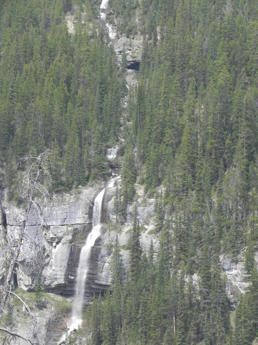
Day 2 we took a boat tour down St. Mary Lake with a guided hike to St. Mary Falls. Lots of great info, including the sobering statistic about retreating glaciers in Glacier National Park. In 1850 there were estimated to be about 150 glaciers. Approximately the same number in 1910 when the park was established. In a 2015 census there were 26 and predictions vary from 2030 to 2100 before all are gone. If you weren’t sure about accelerated climate change, that should help settle it. Saw several of the 26, and up close on Saturday to the Grinnell Glacier.

IMG_4093

The hike to St. Mary Falls took us along some of the burn area from the 2015 fire, with more fascinating examples of how quickly the forest recovers. Wildflowers, underbrush, a few baby fir trees, and lots of tree skeletons. Then there was the falls.

In the afternoon, we headed to a different section of the park called Many Glacier and a 4 mile hike to Red Rock Falls. Best if you can have the sound up to hear the rushing water (and the rocks really are red)!

Saturday was a return to the Many Glacier area and a marathon 12 mile hike with 1600′ elevation gain past Lake Josephine, up to Grinnell Lake then up to Grinnell Glacier. Amazing.

Of course, we’ve seen some wildlife here: a brown bear that waltzed through the campground while we were at an evening Ranger Talk, a mama and 2 cubs munching in some brush along the road, a family of deer on the trail to Grinnell Glacier, a moose getting dinner along that trail and another getting a drink in one of the lakes we passed. Fun.

Here’s the slideshow with other pictures (sorry if there are some duplicates).

This slideshow requires JavaScript.

And today we head further south, to Livingston, MT, near Bozeman. I reached out to a Honeywell friend we haven’t seen in decades who lives near there and we’re having dinner with them!

North Cascades to Grand Coulee Dam to Coeur d’Alene, Idaho

Screen Shot 2018-08-28 at 8.30.44 PM

Our drive Saturday through the North Cascades was one of those days where the weather tried, but couldn’t fully hide the beautiful sharp mountains. This area is called the “American Alps” for a very good reason. Some crazy steep, rocky slopes up into the clouds along Route 20 over and out of the park.

Stopped for lunch at the SweetRiver Bakery in Pateros Washington, another very unassuming spot with a very delicious menu. Went crazy with a sandwich for April and for me, a huge salad, huge bowl of soup, a couple cookies and loaf of 7-grain bread. Yum.

So glad we made the stop at Grand Coulee Dam. Did you know that “coulee” means river bed or creek bed or any other outflow zone? Lots of interesting history about the planning and construction of the dam which was built during the Depression, and it is every bit of Grand. It is the largest hydropower producer in the USA, at about 1,700 MW capacity.

DSCN0541

IMG_4014The campground at Spring Canyon Park was spectacular, though we learned (again) the lesson that we should check if there are better sites available before setting up. You can see our trailer partially under the carport-like roof in the lower right of this photo, and the view from the campground. Stunning. (Ask for the full story about parking under that awning…) The photo on the right shows the view from our window.

Full confession: Both of us grew up on the East Coast. Yes, we spent over a decade in Minneapolis a while back where all our kiddies were born, loved it and made many great friends, but these trips are working wonders on our ingrained expectations for so many spots across the middle 90% of the continent. This stop is a prime example, with an unfairly low bar for what we’d find in the Idaho panhandle.

IMG_4023The short  route between Grand Coulee and Coeur d’Alene was another surprise, with rolling hills of hay and possibly wheat stretching from horizon to horizon, mile after mile. This typical shot reminded us of the “Loneliest highway” in the Great Basin region in Utah. So different from a few hours back in the North Cascades.

We spent the entire time trying to figure this place out…much of the city has a newly-built, hip vibe with restaurants and neat bars galore. Coeur d’Alene, or CDA to the locals, has a deep history, named by French trappers after the Native Americans here, the name meaning “heart of an awl” given their many skills. Lumber and sawmills were the first boom after the 1906 San Francisco earthquake and a silver mining rush, with tourism creating a recent wave of development over the past couple decades. Tough to reflect all this in pictures.

Explored the waterfront and huge park on Sunday afternoon, including a hike around Tubbs Hill with surprisingly woodsy trails and some great views of Lake Coeur d’Alene. Long bike ride Monday up the Centennial Trail along the lake.

IMG_4035Blackwell Island RV Park was filled with motor home rigs, was right on the Spokane River and a bike ride from downtown. Nice. Here’s one view showing how close we are to the river.

And today we head to West Glacier, where much of that part of Glacier NP is still closed due to the fires. Most likely will shift to the east side of the park after talking with the locals. Flexibility!

More orcas, and the North Cascades

IMG_9310Had to take this shot of Padilla Bay across from our site at Bay View State Park just to prove that there really is a Bay View. It cleared up quite a bit late Thursday.

The whale watching trip on Friday, August 24, with Island Adventures was very different from the one we took with Sea Wolf Adventures out of Port McNeil on Vancouver Island, but no less fun to see the orcas. Saw two transient pods – one the onboard naturalist identified as a pair of males who had split from their family recently. Beautiful animals. The term Killer Whale turns out to derive from the original Spanish explorers who called orcas “Killers of Whales”. Over time that was mis-translated and mixed up to convert to Killer Whale, which of course carries a very different meaning. Interesting.

It was a bit chilly on the water, but of course the best part of the day was having Heather join us!

IMG_3959

IMG_4002It was  a bit unusual for us to do something big then travel to the next stop but it worked out great. Had a late lunch in Sedro Wooley at a fantastic spot that was combination grocery, deli and general store – great soups and tender, flavorful brisket. Then on to our campsite at Newhalem Campground in North Cascades National Park. This picture has a couple of stories. When we arrived (with Heather), our site was the short “pull-through” to the right in the picture, that we managed to set up in. The next day we decided to move across to the back-in site on the left so we didn’t feel crammed in and unhitch more easily. Also note in the picture that to the right the forest is burned from a 2015 fire, and untouched to the left of the road.IMG_3962

Happened upon events celebrating NOCA 50, the 50th anniversary for when North Cascades park was established. One of these was a performance in the amphitheater by the American Wild Ensemble, which we decided at the last minute to walk to. Turns out one of the seven musicians was a classmate of Heather’s in high school – how cool is that?? Turn up the volume on the video so you can get a taste of the some of their music (this piece non-traditional). The next day April and I then saw them playing along one of the trails – sounds odd but a bit magical to hear as you come upon them in the woods.

IMG_3993

Caught some beautiful views of the Skagit River during the morning run with Heather and the doggies.

After Heather left, April and I took a hike along the river to the Gorge Powerhouse, which is part of a series of hydro projects along the Skagit River that provide 25% of the power for Seattle. Lots of history here, including a small hydro project in 1921 and this larger one in 1924, with what was and still is a tourist attraction including gardens, colorful lighting and music at Ladder Creek Falls. Gorge-ous!

Today we head to Grand Coulee Dam!


San Juan Islands, smoke and a big surprise

IMG_3943The continuing story about all the wildfires in this chunk of the continent is a continuing story of smoky, hazy views for us. The campground at Bay View State Park is on beautiful Padilla Bay…and we were able to see the bay “view” off and on until our last day here. The bay is very flat and the tide about 8′ so the marsh extends out about as far as we can see at low tide and boats, etc. rest on the mud. And every view has a unique tint. Interesting.IMG_3936

IMG_3950The big event during our stay here was a birthday present for April: Heather flew out from DC on Thursday and surprised April at our delicious birthday lunch at Seeds Bistro in La Conner, arranged by Evan and Lauren.

The day before, on Wednesday, we drove down to Whidbey Island and walked the Bluff Trail at Fort Ebey State Park. Easy to see that the views would have been stunning without the haze…but still gorgeous walking along the high bluff over a rocky beach. Look closely at the all-gray shot and you can barely see a sailboat not far offshore. Also shows the many shades of gray between water and sky.

We’d heard about “flag trees” (didn’t know they’re actually called Krummholz!) and saw some classic examples on our guided hike at Hurricane Ridge in Olympic National Park and there were some stark examples along this bluff.

DSCN0489

Stopped for the view at Deception Pass, named by George Vancouver because it made him think Whidbey Island was a peninsula. And Whidbey Island was named for one of his crew, Joseph Whidbey!

Before lunch Thursday, we walked around the very cute town of La Conner – part artsy, part working fishing village and part touristy. April and I went through the Pacific Northwest Quilt & Fabric Arts Museum. April was in heaven, and it was in a fascinating 1891 mansion.

A second surprise, this one for Heather, is a whale watching trip today (Friday), with Island Adventures out of Anacortes. This will be fun for all of us – April and I saw the northern pod when we were on Vancouver Island, and Heather has never been whale watching. Hopefully we’ll see plenty and the air will continue to clear! We’ll then continue on to our next stop, Newhalem Campground in North Cascades National Park. Fun that Heather will join us as we travel between campgrounds!

Mt. Ranier, Mt. St. Helens and more rendezvous

When it rains it pours (and it hasn’t rained much out here), and our stay south of Seattle at Lewis and Clark State Park the past weekend (Aug 18-21) coincided with more friends’ visits to the area. All of our best friends (Fishers and Benedicts) from Raleigh happened to be in Seattle! Had dinner in Olympia Saturday with Tom and Lori, Lori’s sister Jane and hubbie Joe. Went hiking on Mt. Rainier Sunday with Fred and Debbie, son Michael and his wife Stephanie. So much fun to see them and catch up on Raleigh and family news!

IMG_3931Saturday after setting up we took some short hikes around Lewis and Clark State Park, which boasts one of the few remaining stands of Old Growth Forest in the state. These trees are massive, and fun to see in a regular park. And the moss is everywhere, as it is in many places in this part of the country!

On Sunday, we met up with the Benedicts at the Paradise Visitor Center in Mt. Rainier National Park. On recommendation of one of the friendly Rangers, we managed to avoid the big crowds and hiked the Moraine trail, then up a bit and back down to the Visitor Center. Saw some very cute marmots performing for the hikers, stunning views of the peak and some of its glaciers, some spectacular waterfalls and equally stunning runoff rivulets with wildflowers and moss, making for an elfin wonderland.

Took this video from the end of the Morraine Trail, at an overlook that felt like about 500′ above the glacial melt “river” below us. Captures the view pretty well (look closely for where the river pours out from the rocks like a spring) but not the sheer scale of the scene…you’ll have to imagine that part!

After we split up, April and I headed to nearby Narada Falls and hiked up and around to Reflection Lake. More fantastic views and the waterfall, which we saw at the end of the 3 mile hike, gave a good reason for the packed parking lot.

Monday we woke to a return of the hazy, smoky skies we’ve seen off and on the past few weeks, so we had to use some imagination to see Mt. St. Helens – so I got some great shots of nothing. The films and exhibits at the Weyerhauser Center and at the Johnston Ridge Observatory Visitor Center were outstanding, with fantastic video and incredible photos and stories from the May 18, 1980, eruption. One factoid I was unaware of is that the sound of the blast could not be heard in the vicinity of the mountain. The force of the explosion carried the sound waves up so forcefully that they were blocked from radiating outward, and bounced off the upper atmosphere. So those in most danger could see the initial eruption but heard nothing from the explosion itself.

The hike April and I took on the Hummocks Trail was very interesting – creepy to realize we were walking on the debris field that had been a wasteland 38 years ago, but with lots of aspen groves, other vegetation making a comeback, and a huge beaver dam with the beaver’s lodge right off the trail. Fun.

Today we head north, past Seattle back to a site about due east of Victoria on Vancouver Island, Bay View State Park – about as far northwest as you can get in Washington.

Olympic Peninsula, Part II…and a cosmic coincidence

We’ve all run into friends in unexpected spots, sometimes more unexpected than others. Got a call Thursday evening from one of our best Tufts friends who lives in CT and just happens to also be nearby – in Port Angeles a day after we were there! Had a wonderful brunch (TBS, OP edition) Friday with Pierre and Martha after showing them our traveling estate. TWTFOPD…img_2692.jpg

DSCN0427Our drives through Olympic National Park underscore what a variety of gorgeous scenery there is here: rocky peaks and glacier-smoothed mountains, rain forest vegetation, endless forests with massive trees, deep clear lakes (e.g., this shot of Crescent Lake), the Strait and the Pacific. We’ve seen them all, briefly. This is another area we could return to and spend a lot more time exploring.

IMG_3892It turned out that the idyllic campground by the ocean, Kalaloch, was a bit of a zoo with people lined up for the few first-come sites available, so we stayed for our reserved one night and didn’t try for a 2nd. This would be a perfect spot to linger with the right site – the beach is stunning: wide smooth sand, a few strategically placed rocks offshore and a line of huge driftwood logs along the short embankment. Took a few walks, a nice run in the morning and watched the sun peek under the cloud layer for a stunning sunset. Chai had a blast chasing after the gulls. This was our furthest westward stop (can’t get much further) and our only visit to the Pacific.

Here’s an interesting shot…guess what it is.

IMG_3883

IMG_3902After our brunch Friday, we had our shortest drive ever, about 30 minutes, to Lake Quinalt, another gorgeous inland lake in the Olympic National Park. The interesting attractions here are the rain forest vegetation, with moss and “goat’s beard” hanging from every branch, huge fields of ferns, and gi-normous trees. Including this one, which is the World’s Largest Spruce Tree! 58′ 11″ in circumference, 191′ tall and a score of 922 AFA points!!! (Note that I wasn’t able to get the whole thing into the picture – it was that big!!!)

IMG_3906While the site at Quinalt River Inn was nothing special, it was perfect for what we needed and had easy access to everything. Today we head further east, to one of many places with Lewis & Clark in the name, Lewis and Clark State Park in Winlock, WA.

The Olympic Peninsula, Part I

IMG_3849Subtitle: Back in the USA! Made the crossing from Victoria, BC, to Port Angeles, Washington, Tuesday on  The Coho, a much smaller ferry than the crossing from Vancouver. Similar to passing immigration and customs into Canada near Thunder Bay a month earlier (and any border crossing hauling a complete kitchen and pantry (and bear spray and two dogs)), we were a bit anxious about getting the dreaded “Pull over there, please”. This time was even easier than the 90 second conversation heading north, though without the dog biscuit treats. The boat ride itself was good, though I don’t think Chai would agree with that. Once again, fun to be the oddball travel trailer, mixed in with the big-boy semis and all the cars.

IMG_3879The Olympic Peninsula is gorgeous, unique in its topography and currently shrouded in the same smoky haze that’s everywhere out west these months. Our reserved site at Salt Creek Recreational Area was tight, next to the washrooms and without power/water (that’s not a big problem), so after the first night we moved to this site. What would normally be a stunning view was not too shabby even with the fog rolling in.

The shoreline around the campground has the rocky coast feel of Maine, with kelp and seagulls floating in a band right off shore. The doggies loved frolicking on the beach and rocks that were about 100 yards from our trailer…plenty of great smells down there!

DSCN0425Took a drive into nearby Hurricane Ridge of Olympic National Park, which is about 95% unimproved backcountry access. This was a “cheater hike” since we climbed the 5000 feet to the Visitor Center by car, then took a leisurely guided hike and another short hike to one of the peaks for some (potentially) spectacular views. Smoky haze, but still gorgeous. This picture kinda sums it up, with the sign showing the “real” view. It would have been disappointing if it wasn’t so beautiful in what we could see. And, as usual, we learned a lot from the ranger on the guided hike. The area is a mix of land carved by the glaciers and land that was above the glaciers. This means there are species unique to the area as a result of the isolation during that time, like the Olympic Marmot!

Screen Shot 2018-08-15 at 6.24.54 PMOh, one more thing. All you closet geography geeks (You know who you are – those who really liked the shot of the border posts from Waterton Lakes!) will get a kick out of this picture from a trail down to the shore very close to our first campsite. It marks one of the turning points of the US-Canadian border, just offshore from this post on Tongue Point (where we are). Cool, huh?IMG_3852


Today we shift from the Strait of Juan de Fuca at the north side of the peninsula, to the Pacific Ocean and Kalaloch Olympic National Park campground.

Victoria, BC – and best garden ever!

The drive down 2/3 of Vancouver Island was our longest so far but not as grueling as expected – about 5.5 hours of drive time and 7.5 of total time. Same basic routine, with great scenery along the way and a fantastic long break for lunch at another smallish-town find by April, the Wild Poppy Bistro in Ladysmith, BC. The Burrito Bowl and April’s Polenta Fritters far surpassed, as we so often discover, the low-key rustic feel of the surroundings.

Victoria is at the southern end of the island, the Provincial capital and with a bigger feel than its population numbers indicate: 80K in the city and 360K in the regional district. Our RV park was to the north of Victoria proper in Saanichton, one of many communities in the region. Lots of fruit and vegetable farms, throughout, and near to the highlight of our stay, Butchart Gardens. We’ve now been to a lot of famous gardens on our travels and this one tops the charts. It was crowded but bearable, even with the dogs. (A fancy garden that allows dogs?? And they were, overall, well behaved. They even performed well as quasi-therapy dogs for the many people old and young, who asked to pet them and had the best time. Even Chai seemed to love the attention.) The day was overcast so our pictures are meant to show more of the volume and variety of flowers rather than any brilliant money-shots. Spectacular.

In the first picture, note the size of the hedge relative to the people standing directly in front of it. The place was filled with meticulously trimmed hedges like that one, frequently 15-20′ tall. Put that on your yard work to-do list!

IMG_3832
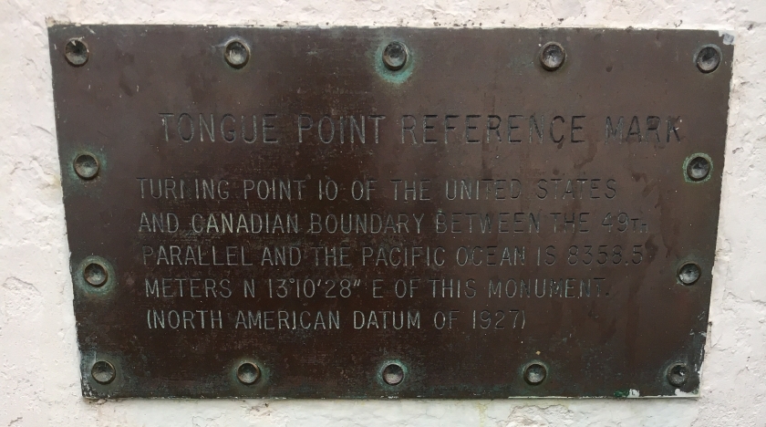
The afternoon included lunch at a farm-to-table cafe that’s part of a large farm stand. Why don’t more large farm stands to that? Simple menu but outstanding flavors! We happened to be next to The Largest Little Air Show, which was the first big-time radio-control air show I’ve seen. Jets, biplanes, formation flying, normal-looking models and some pretty wacky ones, like the Snoopy-on-Doghouse thing that apparently flies. Next was a visit to De Vine Vineyards for some wine and craft gin tasting. Spectacular view across the islands and water over to Washington, delicious – and different – white wines and gin made from grapes with farm-grown botanicals for a zillion flavors.

IMG_3838Monday brought us into Victoria and a visit to the Royal BC Museum. A particularly interesting exhibit filled in more info about the indigenous people beyond what we learned on the Sea Wolf Adventures Grizzly tour. British Columbia seems to be doing a better job than anywhere with their efforts at recognizing history and dealing with the past.

IMG_3839Lunch at 10 Acres Bistro was another taste treat. A curry rice bowl for me (yes, that’s a kale chips garnish), and fried halibut for April. And they were another ban-the-straw spot, which seems to be a thing in Canada, at least a lot more of a thing than anywhere I’ve been so far in the States. Hopefully a trend that will spread southward!

IMG_3840

Here’s the spot we’ve been at at Oceanside RV Park – excuse me – Resort, and now we head back across the border on the ferry to Port Angeles, Washington and the Olympic Peninsula. We’ve been in Canada since Friday, July 13th so it’s been almost exactly a month!

IMG_3842


Grizzlies, Orcas, History…and so much more!

As the location of the largest concentration of orcas in the world plus plenty of grizzly bears and other wildlife, you can imagine the number of tour operators even in this remote north end of Vancouver Island. Somehow April found Sea Wolf Adventures which turned out to be an incredible combination of new boat, passionate and knowledgable guides, cultural and historical context, tasty food, phenomenal wildlife sightings and incredible scenery. (Sounds a bit over the top, eh? Well, it was all of that!)

Thursday, August 9th started with a thick fog and low tide – it’s about a 15 foot tidal swing here. Look closely at the photo on the left…about 300′ out to the dredged channel where the bigger boats are docked. And yes, that’s a bald eagle through the mist on the right, taking off from the jetty as our boat pulled out.

DSCN0308

The company is owned and operated by local indigenous people whose heritage goes back literally thousands of years in the area. This was more than a boat ride to see a bunch of cool  animals in the wild…it was also a well-done lesson in the history and some of the many issues of the culture. From the ecological problems relating to salmon farming to the long-lasting impact of Canada’s Residential School System, our guides Kodi and Shari provided the right amount of context for a fascinating day. Also fun that the few people in the group included folks from Germany, Austria, Scotland, The Netherlands, Vancouver Island, Pittsburgh and Ohio. Some great conversations throughout the day. We made stops at the community of Alert Bay which grew through the ’50’s and ’60’s as indigenous families moved villages there to be closer to the children who had been taken from them, and their historical villages that had been abandoned – including Shari’s mother’s village. Note the size of the posts and beams for one of the traditional long houses from that village. Also note the petroglyphs on the cliff – Kodi pointed out that these are likely from 1792, showing the sailing ships from explorers who came through that year.

But of course the day was mostly about the animals and scenery:

We were fortunate to see the larger of two groups of orcas in what’s called the northern pod, which is healthier than the southern pod. A bunch of adults and many young ‘uns, all having a great time playing, and the sounds they made every so often were too cute. Three photos near the end of that sequence are from when we were watching one or two humpback whales do their thing. Note the large flock of seagulls mostly sitting on the water, and the shot with a slight disturbance on the water and all the seagulls in the air. I’ll update this when I get the photo from one of the other 10 people on the tour who caught just the right moment when the whale came up through the school of fish under that batch of seagulls and sent the seagulls scattering. It was stunning to watch…! And the bald eagle, one of many seen, was just sittin’ there as we walked back to our car.

Friday afternoon we took a 4-hour sea kayaking tour south from Telegraph Cove. Clear water (reportedly some of the best diving in the world…from a biased local), fascinating kelp clumps, rocky islands and shoreline, a few bald eagles and lots of woodsy views. On the way back there was a huge fog bank across the strait that hung there ominously but didn’t seem to move. Part of what they call this month: “Fog-ust”

This is our campsite…but the view doesn’t capture that to the right is the stunning strait we kayaked along, and slightly to the left is the cute little harbor of Telegraph Cove.

IMG_3816

And here’s where we’re heading today…Victoria on the south end of Vancouver Island.

Screen Shot 2018-08-10 at 6.06.16 PM

Vancouver and Vancouver Island

Our stay in Vancouver included a chore/errand day (when you’re on the road for months, ya kinda need to do this, too) and a day hitting two of the big sites in the big city, Stanley Park Island  including the Vancouver Aquarium, and Granville Island. The campground was adjacent to the town of Fort Langley and Fort Langley Historical Park, another interpretive park at the site of a Hudson’s Bay Company trading post. Interesting to see the accurate reconstruction including one large building (to left in photo) that is original.

IMG_3780The drive through Vancouver, Stanley Park and lunch/wandering at Granville Island was a typical tourist day. Would have been nice to have our bikes and full day for a ride around and through Stanley Park Island, which is the big city park, but we’ll do that next time. There were several of these peculiar trees, a result of a big windstorm a while ago that snapped off a bunch of their big trees. The Aquarium had a particular focus on jellyfish with numerous well-designed displays.

IMG_3793

Our drive from Vancouver to Vancouver Island included our first ferry crossing, and this was a big one. After a lifetime of taking the ferry from Woods Hole to Martha’s Vineyard and several other big-ferry trips, it was still a lot of fun to be part of the big machine towing our little trailer. And the views during the crossing were, not surprisingly, stunning on a gorgeous clear sunny day. No whale sightings, though that’s reportedly pretty common. That is yet to come…

The drive up Vancouver Island has taken us into some of the most remote country yet. A bit eerie driving hours through wooded mountains with small towns or any roads or houses only every 40-50 miles. The campground is at Telegraph Cove, a gorgeous harbor with some interesting history that includes a takeover of the mill and town to produce lumber for the Canadian military during WWII.

The big activities during our stay at Telegraph Cove include an all-day boat tour with Sea Wolf Adventures to see grizzly bears and orcas and other wildlife, and a half-day sea kayak tour.

Kelowna, BC: Lakes, wineries and a family visit

Not surprisingly, the drive from Revelstoke to Kelowna took us past yet more gorgeous mountains with glimpses of tall waterfalls, many avalanche sites and steep slopes with endless trees.

Our 2-night stay at Orchard Valley RV Park was a bit unusual and so much fun. Got to see Tom, Renee, Tommy and Joan (April’s brother and family) who coordinated a visit to Renee’s step-mother, Amy. One of Amy’s daughter’s, Christine, lives there and we spent the weekend with all of them, including Christine’s boyfriend, Cody. We ate delicious meals – starting with a spectacular home-cooked feast by Amy – and visited four of the zillion wineries in the region.

IMG_3733

Kelowna, in the Okanagan Valley, is known for its fruit (which explains the RV Park located in an orchard), mild climate and huge Okanagan Lake so it’s become a popular holiday and retirement destination. I’m making this up, but it seems to be the Napa of Canada, with wineries and vineyards everywhere you go.

The wineries and views were spectacular, but the real fun was spending time with April’s family and extended family.

Headed to the Vancouver ‘burbs on Sunday, starting with the longest steep climb we’ve had yet as we left Kelowna on 97C. Anyone who has pulled a trailer knows how that goes – no problems and the Jeep passed the engine-temp test with flying colors, bouncing around the red-line limit as I managed the a/c and speed. Now in Fort Camping Campground at Fort Langley, a very cute tourist town along the Fraser River. Looking forward to a couple days of errands and seeing a bit of Vancouver!

Great food, great beer and more great mountains

Stepping our way westward again, from Banff NP through Glacier NP (nope, not that Glacier NP, the Canadian one) and now just outside Revelstoke NP. Only one night in Revelstoke then on to Kelowna where we’ll get to see April’s brother and family who will also be there – fun!!

By the way, the smoke at Banff I talked about at the end of the last post turned out to be a major fire in Kootenay NP along the Hwy 93 that we took from Radium Hot Springs to Banff. Got the highway shut down for several days now so it’s a pretty big deal. Lucky we traveled when we did and not a few days later!

IMG_3713The drive yesterday (Thursday, Aug 2) was entirely along Trans Canada Highway 1 through mountains that, incredibly, seemed even taller and more scenic than what we saw along the Icefields Parkway – though without as many glaciers. Made it into Pacific Time so nice to have the extra hour.


Lunch was in Golden, BC, at yet another of April’s diamond-in-the-rough finds. Golden is another ski town, with Kicking Horse Resort up the hill. Turned off the highway, down a very industrial street past the NAPA auto parts store, an HVAC contractor and similar real-people businesses to the Bluebird Cafe. Had some of the best pho ever, April had a spectacular turkey sandwich and we couldn’t resist the fresh-baked cookies, plus one to go. Note the cookie was half-eaten before we got the main course…

Our one-night campsite at the private Lamplighter Campground is nice but the main attractions included a long drive up the Meadows in the Sky Parkway at Mt Revelstoke NP, complete with some spectacular views. Tried a triptik panorama of the town and the same Columbia River we saw a week or so ago. This time it’s flowing southward on its way to the US of A after its journey northwest around the big mountain range we just went over.

Here’s the same map of the Columbia River route I included a few posts ago. Cool, huh?

Screen Shot 2018-07-26 at 5.56.16 PM

At the top of the parkway in Mt. Revelstoke NP, it turned out we couldn’t hike up to Heather Lake (sorry, Heather) because they had a recent grizzly get aggressive with a dog and hikers on the trail…so no dogs allowed in that section. But got a great view of the river upstream of the Revelstoke Dam and little Balsam Lake. Like many alpine lakes, this one dries up in the summer since its source is winter snowmelt.

The other main attraction of our short stay was discovery of another fantastic craft brewery. Realized we haven’t been to one since Two Harbors – an inexcusable dry spell – but finding the Mt. Begbie Brewery (best brewery in Canada, 2017) made up for it. A spectacular flight of a nitro chocolate stout, brown ale, honey ale and cream ale paired with one of the most delicious cheese boards we’ve had.

Finally, a brilliant rainbow over my morning running route with the dogs (taken Thursday evening as we dodged one of the many thunderstorms in the area). You can’t quite see the double rainbow but it’s there…

IMG_3729


“This is the best yet!”

DSCN0215We say that a lot and Tuesday, July 31, (a great date – Happy B’day Evan!) was no exception. Starting with the moonset over yet another incredible mountain view on the drive to Johnston Canyon, we were about the 15th car in one of the two parking lots when we arrived around 7:30. By the time we left about noon both large lots were full and a long line of cars were parked along the road.

The hike up Johnston Canyon is one of those must-see spots in the Banff area, which explains why it’s so popular. This 7.5 mile hike combined a gorgeous mountain stream (Johnston Creek) through a narrow rock canyon, a variety of incredible waterfalls, views of the creek, hills and mountains beyond and, at the turn-around point for a smaller crowd, strange and colorful bubbling thermal springs called the Ink Pots.

Of course, lots of pictures but I’ll start with two videos then you can skim through the rest if you like. Turn the sound up for the full effect.

DSCN0216Note the way the trail is cantilevered over the creek – this was only one of several long sections like that. Another example of formerly-afraid-of-heights April taking it in stride. (On the way back there was an almost-constant line of people and it was an interesting challenge walking these sections with the two dogs. I detached Chai from the 2-dog hiking leash and April led her while I kept Enzo pinned to the side. It worked, but was a lot more enjoyable when we were essentially alone on the walk up!).

Took these pictures of the upper falls on the way up and back at about 8:30 and 10:30am; notice how different it looks in direct sunlight. Highlighted the obvious fact that photos in narrow canyons (or similar) depend so much on where the sun is at the moment you’re snapping the picture.

A variety of shots of the lower falls and other scenic spots along the trail.

Lastly, on this hike, was the bizarre Ink Pots. This is a series of colorful thermal springs that also blurp up gases every few minutes, creating a serene (since few people had arrived at that point) setting.

After lunch we drove over to the Cave and Basin National Historic Site, famous as the location of the first Canadian National Park and fascinating for its history as another of those curative (mildly) sulfur hot springs developed for and frequented by wealthy tourists in the early part of the 20th century.IMG_3695

These hoodoos are a relatively short walk from our campsite – a nice after-dinner walk with the doggies on Tuesday evening.IMG_3698

Wednesday we again rose early, on the road by 6:30 and still got to a rapidly-filling parking area at Lake Louise. Hiked with the pups past Mirror Lake and up to Lake Agnes, around the lake then up and over the ridge back to Lake Louise.

These are similar shots of Lake Agnes, taken from my iPhone and from my Nikon. Guess which is which….

DSCN0238IMG_3700

These are some of the views of Lake Louise from the trail back – note the tiny dots that are canoes on the lake, and the odd double-shadow. Never did figure out exactly why that was there, and it disappeared after a short time as we got further down the trail. The large building at the end of the lake is the lodge.

This one gives a small view of the crazy crowds that had arrived when we got back down to the lodge area.

IMG_3703


IMG_3705

With our early start, we were done by a reasonable lunchtime and April managed to find another phenomenal restaurant, located in the Canadian Alpine Club Hostel building just around the corner from the madhouse of the nearby mall, Bill Peyto’s Cafe. Got to enjoy some real poutine, a beer and some incredible roasted pepper and chorizo soup in a quiet spot.

If you’ve stuck with this long post and enjoyed the waterfall videos, here’s one that shows the view from one side of Lake Agnes, with the trail heading off across the surrounding bowl of landslide rubble, then back to a view of the Lake Agnes Tea House.

(By the way, if you’re wondering about whether we’ve been impacted by all the forest fires in Canada and the US, the answer has been “no” until now. As I’m finishing this, sitting at the campsite picnic table, I’m getting a dusting of ash and the air has gotten very smoky. Eerie. Not sure of the source, but there are several large fires a long way to the west.)

Today it’s on to Revelstoke!

Sunshine Meadows, and The Icefields Parkway

All those great things you might have heard about the region including Banff National Park and Jasper National Park? Pure understatement. There’s a good reason Banff NP is Canada’s oldest, and many reasons this area has a reputation for incomparable scenery. Also many very good reasons why the Icefields Parkway through Banff NP and into Jasper NP is known as the most scenic highway in the world.

DSCN0167We had a long first full day, with hikes in the Sunshine Meadows area west of town. This is a top-rated, massive ski resort in the winter cleverly re-branded “Sunshine Meadows” for some incredible hiking. April has been afraid of heights all her life and seems to be less-so…voluntarily took the gondola (done this before, not enthusiastically) then the Standish Chairlift up to the top. Amazing. And the views from the trails were incredible. Did a wandering circuit on the trails around Rock Isle Lake, Grizzly Lake and Larynx Lake, then walked down to the gondola station just to get a different perspective. Learned a lot about the flowers from a couple of trail volunteers. We noticed a thick smell of locker-room clothes or something like that, which turned out to be white-flowered valerian. Indian paint brush, the edible fireweed, some Columbine and many others including the western anemone which is also called “hippie hair”.DSCN0163DSCN0169DSCN0172DSCN0173DSCN0175DSCN0178DSCN0179DSCN0180DSCN0181

Back to the trailer to get the dogs then a drive a shorter walk at Lake Minnewanka, which is a large dammed lake just west of Banff, fed by the aptly-named Cascade River. Besides being gorgeous and a nice place for Enzo to take a swim (far down the trail away from the crowds), its interesting history includes the 1941 version of the dam that submerged the resort town of Minnewanka Landing. A bit controversial at the time, as you can imagine.

Monday June 30 was another day with a long hike…7.5 miles round-trip to Helen Lake that included an elevation gain of 1,500 feet to an elevation of about 7,500′. Glad we got there early as there was a pretty steady stream of hikers heading up as we went down, but the views were phenomenal. First stop, though was Hector Lake.

DSCN0190

Then these shots from the hike up and down to Helen Lake. Had to get that last one of the weathered stump…the glaciers and mountains and flowers and views are so incredible, but I thought the lighting and texture on this poor, ignored dead hunk of wood was pretty cool.

DSCN0197DSCN0198DSCN0200DSCN0201DSCN0203DSCN0204

DSCN0207
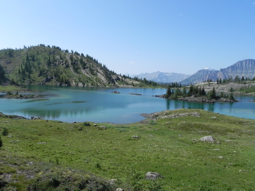
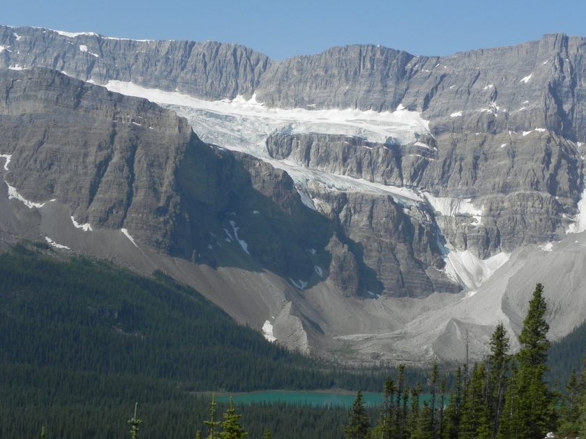
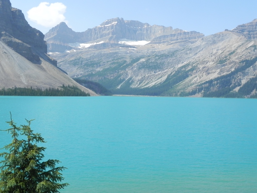
Made numerous stops along the Icefields Parkway, including Bow Lake and Peyto Lake, which really does have maybe the best overall postcard view (you were right, Dave R!). The water in many of these lakes looks PhotoShopped, or artificially colored in, but that’s real. The vibrant, milky turquoise look comes from “rock flour”, the fine dust that results from glaciers scraping along rock.IMG_1371 2

DSCN0206DSCN0209DSCN0212

This last shot is from the Columbia Icefields Centre, which is a bit touristy but incredible vantage point for the Columbia Icefield and Athabasha Glacier, One of the informational signs there pointed out that not long ago the glacier used to extend all the way to the highway, visible in the foreground.

DSCN0213

More hikes and more pictures to come. We could easily spend a lot more than four days here!!!

Banff

Most people have heard this is an incredibly scenic area, many friends have been here – this is our first time and it’s easy to see why everyone raves about it. The drive up from Redstreak Campground at Radium Hot Springs to our current site at Tunnel Mountain Trailer Court in Banff was a relatively short one so we stopped for a hike on the way. So glad we did. There’s something about river gorges that is so, well, gorgeous. (Evan just rolled his eyes.) Stopped at a short hike to see the Paint Pots, a surprising area of clay that’s been used as a source of ochre for paint for hundreds of years. There was a commercial mining operation in the first decades of the 20th century with plenty of machinery still scattered around. Easy to tell the colors must be brilliant under the right conditions of rainfall and spring flow – it was still interesting but a bit worn out when we saw it.

DSCN0151

The next hike on the map was nearby so we debated then decided to add a 4 mile trek to and from this place called Marble Canyon. Wow. Combine the visual complexity of Antelope Canyon, a slot canyon we visited last year, the dazzling turquoise color of Huka Falls that we saw a few years ago and the carved rock of your favorite mountain gorge (e.g., Hamilton Falls in Vermont). Hard to get a sense of scale, but know that the river is probably 50-60 feet below the path in some areas.

The path between Paint Pots and Marble Canyon runs along the Kootenay River and is part of a very large section of Kootenay NP burned in a massive forest fire about 15 years ago. Interesting to see the condition of the forest here compared with our visit to Waterton Lakes NP that experienced the Kenow Fire last September.

Our expectations for Tunnel Mountain Trailer Court were pretty low, based on the name and looking at the campground map when we booked the site months ago. While there are some sections of the large campground complex in Banff, our site is on the perimeter with plenty of trees and a spectacular mountain view in every direction (look closely through the trees at 9700′ Mount Rundie). Nice.

IMG_3664

So many options for what to do and see over the next four days. Our plan, which could change of course, is to take the gondola up to Sunshine Meadows area on Sunday, Johnston Canyon Monday (great recommendation, Dave!), Icefields Parkway toward Jasper with a hike or two along the way Tuesday, and Lake Louise and/or Lake Moraine Wednesday.

The Canadian Rockies

Screen Shot 2018-07-26 at 9.51.55 PM
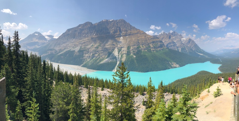
If you look closely at the map for this part of our trek, it’s easy to understand why just about every picture has mountains – BIG mountains – in the background. Left Waterton Lakes Townsite on Wednesday, July 25 and crossed into our 5th province of the trip, British Columbia. (We’ve confessed to each other of gaining a much better understanding of Canadian geography. The provinces this trip have been Ontario, Manitoba, Saskatchewan, Alberta and BC – 5 of the 10 plus 3 territories.) Drove through Crowsnest Pass and site of the 1903 Frank slide, one of the most deadly landslides in Canada. Eerie to drive through the middle of where most of the mountain slid down and up the other side of the valley.

Stopped at a bakery/deli for lunch in Fernie, for yummy curry and plain meat pies, which seem to be a favorite in these parts. It’s a ski town, and Fernie Alpine Resort gets a lot of snow: 29 or 42 FEET, if you believe the link or the outdoorsy-looking dude I asked on the sidewalk in town.

Screen Shot 2018-07-26 at 5.56.16 PMKimberley is another hip ski town with another incredible bakery where we got another couple of meat pies (and other stuff). Our campground was on the Kimberley River adjacent to a huge complex of hiking and mountain biking trails, great place for the morning run with the dogs. Got a great view of the mountains where we went next.

IMG_3632IMG_3631IMG_3633
The drive to Kootenay National Park and Redstreak Campground took us into the Columbia River valley and its spring-fed source lake. Interesting that the Columbia River heads northwest before heading south and out to the Pacific.

Getting into the serious mountains of the Canadian Rockies with endless options for hikes to stunning mountain lakes. Took a 2 km hike after arriving on Thursday along a steep and heavily wooded forest to the big attraction here since the ‘20’s, Radium Hot Springs. We now glow. The picture of the moss is typical of so many photos that don’t capture the full effect – the lighting on the moss clinging to the hillside and the pine smell. Nice.

IMG_3644The pool has a fascinating history and interesting design. The concrete patch in the cliffside is where 113F water comes up from 2.5 km, is piped to that mushroom-shaped thing in the pool and mixed with cool water from the stream that you can see in the upper right to keep the pool at about 103F.

Friday we took 3 hikes to lakes along the road toward Banff: Olive Lake, Cobb Lake and Dog Lake. Note the color of the water as we crossed the Kootenay River on the way to Dog Lake – natural and stunning. Got a great shot of a butterfly resting on some flowers in a viewing site by the road. Luck. In the last shot, notice the clarity of the water at Olive Lake – how easily you can see the logs on the bottom.

IMG_3654IMG_3653IMG_3651DSCN0147DSCN0144DSCN0141DSCN0140DSCN0138DSCN0130DSCN0128DSCN0125

These guys are hanging out on the road leading into Redstreak Campground so we saw them several times. That picture was taken without zoom, by the way…

IMG_3661

Today we head to Banff, and the Tunnel Mountain Trailer Court. This will be a 5-night stay, our longest in one spot!

And into the mountains

So many pictures, so many stories! On Sunday, we made our way out of the plains (barely) and into the mountains of Waterton Lakes National Park, which is on the Canadian border adjacent to Glacier NP. In fact, in 1932, the combination of the two parks was designated the first International Peace Park, duplicated 146 more times around the world. Fun to see the mountains rise out of the flatland.

DSCN0111
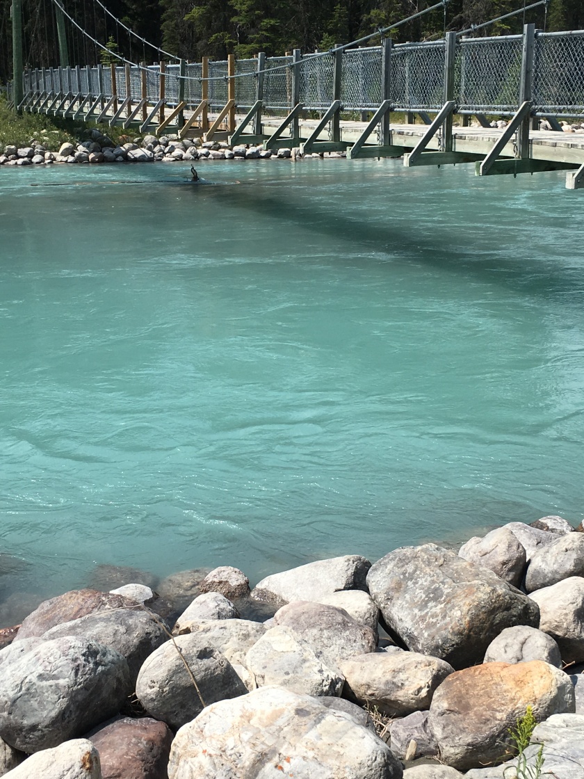
This park, like Glacier, suffered greatly from a huge fire last year, the Kenow Fire, that came within meters of the townsite, with an incredible story of how they saved the many buildings of the town, including the Prince of Wales Hotel from 1923.

The scenery, as you can see, is stunning, with long, narrow Upper Waterton Lake running north-south down into Glacier NP in Montana.

IMG_3613IMG_3617

On Monday we took a boat ride south on the lake into the USA which included a customs clearance to get dropped at a National Park Service outpost called Goat Haunt, inaccessible other than by boat or trail.

DSCN0077

Then we hiked 8.6 miles back up the western side of Waterton Lake, a recommendation from friends Ron and Cathy who had done this hike a few years ago. So glad we did this but the trail was not exactly well-cleared for the first few miles, as you can see from some of the pictures of April wading through the underbrush. Gorgeous views and very interesting to hike from dense pine and aspen forest into the burned-out section further north. One of the pictures shows the line of the US-Canadian border stretching up the mountain across the lake – a clear line all the way to the Pacific.

This slideshow requires JavaScript.

IMG_3618Yesterday we took a long bike ride north and happened upon a momma bear and her 3 cubs rambling down the other side of the road. Too cute, and fun that we saw them just as they came over the ridge, which rapidly produced one of those “bear jams” we experienced several times on last year’s trip.

DSCN0119DSCN0114DSCN0118

IMG_3621The campground and town also have numerous signs warning of aggressive deer, and there are many wandering around the area (though we didn’t see any aggressive ones). But the real attraction for the dogs was the abundance of Columbian ground squirrels, which look like a cross between a squirrel and prairie dog. Hundreds of holes, with about a dozen close to the trailer (the pictures are from inside and outside our door). Non-stop, high-quality doggie TV.

DSCN0122


As a bonus, there’s a gorgeous waterfall next to the campground.


Flat (mostly), but not boring

This is that stretch across the plains of Central Canada, similar but different (of course) from the plains of the Central U.S. Left Riding Mountain National Park in Manitoba with its big lake, hills and lots of forested trails, back down to the highway across the flatlands, spent a night in Indian Head and now sit close to the western edge of Saskatchewan in Cypress Hills Interprovisional Park. Note there aren’t cities of any size along the 533 mile route…think about that, you coastal megalopolis types!

Screen Shot 2018-07-21 at 5.10.33 PM.png

Both days’ drives took us through flat farm country of a scale that one can certainly find elsewhere, with fields stretching from horizon to horizon, roads that go straight east-west and north-south in endless lines, farmhouses and small towns with buildings new and weatherbeaten old. Every trip through this type of terrain is different, however, with plenty to wonder at. In a previous post I mentioned the huge fields of yellow flowering crop – said it was rapeseed but turns out to be canola, so think of this next time you’re shopping for cooking oil.


IMG_3572Turns out canola is alternated with wheat, which we also saw in abundance, along with some corn and what looked to the untrained eye like flax, with stunning blue flowers. Passed by one spot where a yellow blooming canola field abutted a blue blooming flax field – stunning (chose not to turn the trailer around for a picture…).

Lunch Friday was at another of April’s small-town gems, an Italian restaurant in Moosomin, SK, called Isabella’s. Turned out to be a Chinese-Italian place with sandwiches that could have been served at the chic millenial’s spot in your town. Mine was pressed BLT and avocado, and April had a burger.


IMG_3566It shouldn’t be a surprise that each of these small farming towns on the prairie have their diamonds-in-the-rough, and we stumbled on several. Our private campground in Indian Head was perfect for what we needed, but pulling through town we caught this view, then stopped at the bakery I’d scoped out the day before. Fun.


Flashes by too quickly, but we’ve seen dozens of large hawks hanging out on top of the utility poles along the side of the long straight road, and many hawks sitting on the tops of the rolls of hay that are everywhere. If you want a fun 38 seconds, check out this time lapse as we rolled down the road (rest assured, this was done safely, with the iPhone propped up….obviously not securely as you can see at the end!).


Lunch yesterday was at another hidden gem, another spectacular bakery in a dusty town. Stumbled on The Shop Bakery & Deli in Maple Creek not far from Cypress Hills. The pre-made sandwiches (usually a red flag) were beyond delicious: April’s chicken salad and my salami and cheese on a cheddar-and-bacon scone. Better were the pasta and slaw salads, and best (IMHO) was the Haida Gwaii granola bar, named after some islands off the BC coast north of Vancouver Island, where we’re headed. According to the wonderfully friendly staff at The Shop, we’ll be running into these more and more as we head west.


IMG_3589Cypress Hills Interprovisional Park is one of the spots we might have extended our stay, but “the mountains are calling and we must go”. As we drove here it reminded us a bit of Great Basin National Park, where you drive across flat, then mountains (though these aren’t quite as tall). Or maybe the inverse of Palo Duro Canyon SP in Texas, where we drove across the Texas flat lands then…wham…there’s this huge canyon. Lots of trails here, and we happened to pick the night of Canada’s annual Parks Day, a celebration of all parks with fireworks here.

Today we head into the mountains, with a 3-night stay planned at Waterton Lakes National Park,  still in Canada and adjacent to Glacier NP.

A resort lake in the woods…in the plains

Perhaps we’ve finally learned that secondary and tertiary roads in Canada, at least the ones we’ve been on, are not like most secondary and tertiary roads in the USA. Google, of course, likes to take us on the fastest route, which is sometimes a shorter distance and off the main highway. We’ve loved that option as it gets us away from interstate traffic and into more interesting areas. Since we don’t go faster than about 60 mph (now, 100 kph) that’s usually not much of a penalty for travel time – and what’s the rush, anyway?

IMG_3510The route from Birds Hill to Riding Mountain National Park is either entirely along the Trans Canada Highway (Hwy 1, a 2-lane but paved and relatively well-traveled route) then north, or a more direct path – and a few minutes faster, according to Google. Well….turns out to be about 70 km of mostly-straight gravel-and-dust road through gorgeous farm country (Hwy 101 and 26). Not good when towing a trailer. After about 50 km we bailed and turned onto a paved road back down to the highway. Kinda fun, but it led to a long stop at a truck wash after lunch.

Screen Shot 2018-07-19 at 8.11.52 PMIMG_3511Lunch was at Mumzz Kitchen in Gladstone, Manitoba, which had a great menu and enticing website, but not-as-great food. The lack of good cell service makes it tough for April to find and rank eating spots so it’s been hit-or-miss much of the time. Still, this was my first chance to taste poutine, which Evan highly recommended. It’s typically a bowl of French Fries covered in some cheese and lots of gravy. Sounds healthy, eh? 440px-Happy_Rock_Gladstone_ManitobaThis place offered poutine with bbq pulled pork, which was pretty good. The server was amazed I finished that and the taco salad – both are normally main courses. Gladstone had a cute mascot we passed on the way in (Happy Rock = Gladstone). So my question of a Wall Drug or Corn Palace equivalent has been partially answered!

IMG_3512Riding Mountain National Park is not particularly close to any large town but is a good-size lake resort with neighborhoods of well-kept cabins, a small commercial district, plenty of lake activities and a large campground. Similar to many national parks, about 90% of the land area is backcountry which we didn’t get into but, given how beautiful this part is, must be gorgeous. Turned out to thunder and rain during the morning of our day here (2-night stay) but I took the time to make a blueberry “Klutch” for the 2nd time this trip so the trailer smelled great.

We got in a nice bike ride along Clear Lake to a fantastical little garden at The Wishing Well in the afternoon and took some walks with the doggies around town.

Final note about our campsite…while there are many gorgeous and level spots here, we ended up at one with a “healthy” up-slope. To those trailer buffs out there, this meant a full extension of the front trailer jack and front stabilizers and a bit of a reach to the fold-out steps (Enzo had a bit of a crash first time he charged up them :). A nice challenge for me to get the bikes down from the bike rack! IMG_3526

Next stop is further across the plains, at Indian Head Campground, a private campground in Saskatchewan roughly north of the North Dakota – Montana border.

Into the Plains

If you check out the map from the last post, the last few days have taken us from Thunder Bay on Lake Superior across an area that looks much like the lake-y, rocky, woodsy parts of northern Minnesota (well, because it’s adjacent!) and suddenly into farm country. Big farm country.

IMG_3496Our first stop was at Crystal Lake, a gorgeous spot a few kilometers south of the Trans Canada Highway on yet another gorgeous lake. Went out at 3am to check out the stars since we were in the middle of the woods but it was cloudy :(. Collected a bunch of fresh blueberries on a trail along the lake.

IMG_3491On the way, we timed our drive to try to catch the final game of the World Cup over lunch, which worked out perfectly. Was a bit nervous as we drove up to this spot, but the small cafe, with several truckers and one other couple, had a TV which we commandeered to the match. Saw most of the 2nd half, including the French keeper’s screw-up that gave Croatia one of their 2 goals.

IMG_3497IMG_3495
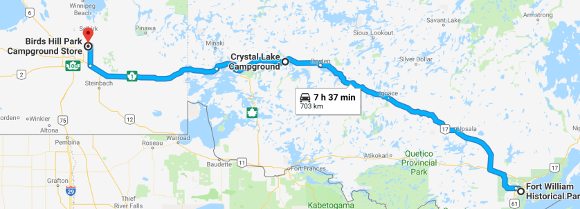
The next leg from Crystal Lake to Winnipeg took us past one gorgeous lake after another with lots of rocky hills. The weather was overcast with occasional light rain, and we decided to add a few minutes to get off “the interstate” (aka, Trans Canada Highway). Our diversion turned out a bit bumpier than we were used to. Still fun, though! And once we got back on better roadway (out of Whiteshell Provincial Park) the sky cleared, the land flattened and we got into the start of some plains farmland. Passed a gorgeous, huge field of rapeseed in full bloom!

IMG_3509Birds Hill Provincial Park is 30 minutes outside Winnipeg (pop. 700,000), far enough and large enough at 13.6 square miles to have space for a large campground, lots of hiking and biking trails and a couple of small lakes. Lots of other campers here but our campsite was on the outer perimeter of one of the many small loops, with trees all around.

Our first (partial) day here was spent exploring the park on bikes, some walking, then a 10 mile solo mountain biking adventure by yours truly along some gorgeous and mostly-level single track in the remote north end of the park. Saw plenty of deer and was on high alert the whole time, expecting to turn a corner and see a bear. Nothing that exciting but I haven’t pushed it that hard in years.

IMG_3507
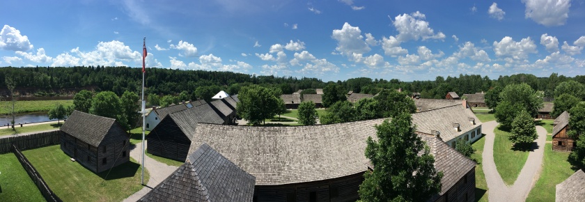
We’d heard great things about the Canadian Museum for Human Rights and spent much of Tuesday there, with a break for lunch at a fantastic nearby food hall, The Forks. The variety and quality of exhibits at the museum leave one with much to think about: how much of the moral coding of every major religious and non-religious doctrine centers on treating others kindly…yet how often we (as humanity, as countries (focus here on Canada, of course) and as individuals) fail at this. I don’t know of a similar museum in the US or elsewhere, so it’s too bad most won’t get to Winnipeg to see this.

So you’ve assumed that Birds Hill got its name from having birds on the hill? And maybe it’s called The Forks because you have lots of choices to eat there? Wrong on both counts! An early settler named James Curtis Bird owned much of the land that became the park. And The Forks, got its name because of its position where the Assiniboine River flows into the Red River.

Today we head deeper into the expansive Canadian prairie. Winnipeg is roughly north of the North Dakota / Minnesota state line and our next stop is roughly above the mid-point of North Dakota. Looking forward to see if there’s an equivalent to Wall Drug or the Corn Palace!

Oh, Canada!

First, one last picture from the banks of the Gooseberry River during my morning run. The deer did not like the dogs looking back at it!

IMG_3469

Highway 61 is well known as it runs from New Orleans to Canada, and especially in these parts as the main (in most respects, only) road northeastward along the North Shore of Lake Superior, which made for easy navigation this leg of our trip. After reading too many horror stories about trailers getting torn apart by border agents (in both directions) I was a bit anxious. Think about how you feel with that packet of souvenir chocolate bars you didn’t declare in your suitcase when flying somewhere, and remember we have an entire kitchen full of food rolling behind us. Then there’s the bear spray…a heads-up from a cousin (thanks, Mary!) that good friends of theirs got in deep trouble due to the two (one they’d forgotten about) cans of pepper spray that they’d bought to use as bear spray. Turns out that’s clearly prohibited as a weapon but true bear spray is fine. Go figure. Anyway, the burly Canadian border guy was very nice and even gave us two dog biscuits for Chai and Enzo!

Our first stop north of the border was Fort William Historic Park in Thunder Bay, Ontario. Thunder Bay seems to be much about industry and shipping, which makes sense since it once was the largest fur trading outpost ever and still is at a good spot on Lake Superior. Best part…they have two craft breweries here, and the one we picked, Sleeping Giant Brewing Company, was huge. Great Nitro Oatmeal Stout!

IMG_3475The RV park is a bit unusual for us…it’s a row of 10 spaces with full hookups in a big field that’s used for parking (and other RVs or tents) during concerts and events. Check out the photo but you have to zoom in to see the gorgeous view across the Kaministiquia River. Note the row of RVs in the picture goes from massive to Mini (us) to tiny, with fun and friendly neighbors. Turns out the bus neighbor is uncle to Jordan and Eric Staal who play for the Carolina Hurricanes. Small world, again.

Friday night we went crazy and signed up for a program called Meteors and Asteroids at the astronomical observatory here which ran from 10pm to midnight. Did you know the value of a meteorite is often based on the story behind it? Yes, this makes for some fraud but also makes for some interesting rocks, and they have a large case full, with some very interesting stories. Meteorite metal is hard and often magnetized, so has been used through the millenia for things like a dagger in King Tut’s tomb. They also have several powerful telescopes we looked through, seeing the moons of Jupiter, rings of Saturn, a ring nebula, twin star, etc. Very cool.

Spent most of yesterday at the Historical Park itself, which turned out to be very interesting and well done. Built in the 1970’s, they’ve recreated the entire fort with re-enactor staff portraying life in 1816, when the Hudson’s Bay Company took control from the North West Company. This was the primary trading point for the fur trade, which itself has a fascinating history linked closely to world events. Very different business strategies and supply chains for the two companies, with the North West Company taking a cooperative approach of working with native populations and the Hudson Bay Company a more transactional approach. The re-creation here includes a full working farm and all the trades of the day, and the buildings look completely authentic. One of the buildings was even built using all original construction methods (hand-hewn logs, etc.). Next time you’re in Thunder Bay, this should be high on your list of things to do!

IMG_3477

Today we start the long run westward mostly along the Trans-Canada Highway. First stop is Lake Vermillion, then just north of Winnipeg. Take a good look at the map of the next few days between Thunder Bay and Winnipeg. Not many towns and lots of lakes so should be a very interesting drive!

Screen Shot 2018-07-14 at 9.30.06 PM